You are here: Home > Network List > TJ - Tajikistan National Seismic Network Stations List
> Station GEZN Gezan, Tajikistan > Earthquake Result Viewer
GEZN Gezan, Tajikistan - Earthquake Result Viewer
| Earthquake location: |
Banda Sea |
| Earthquake latitude/longitude: |
-7.5/127.9 |
| Earthquake time(UTC): |
2016/12/21 (356) 00:17:15 GMT |
| Earthquake Depth: |
152 km |
| Earthquake Magnitude: |
6.7 Mww |
| Earthquake Catalog/Contributor: |
NEIC PDE/us |
|
| Network: |
TJ Tajikistan National Seismic Network |
| Station: |
GEZN Gezan, Tajikistan |
| Lat/Lon: |
39.28 N/67.72 E |
| Elevation: |
1485 m |
|
| Distance: |
72.5 deg |
| Az: |
315.096 deg |
| Baz: |
115.596 deg |
| Ray Param: |
0.053244725 |
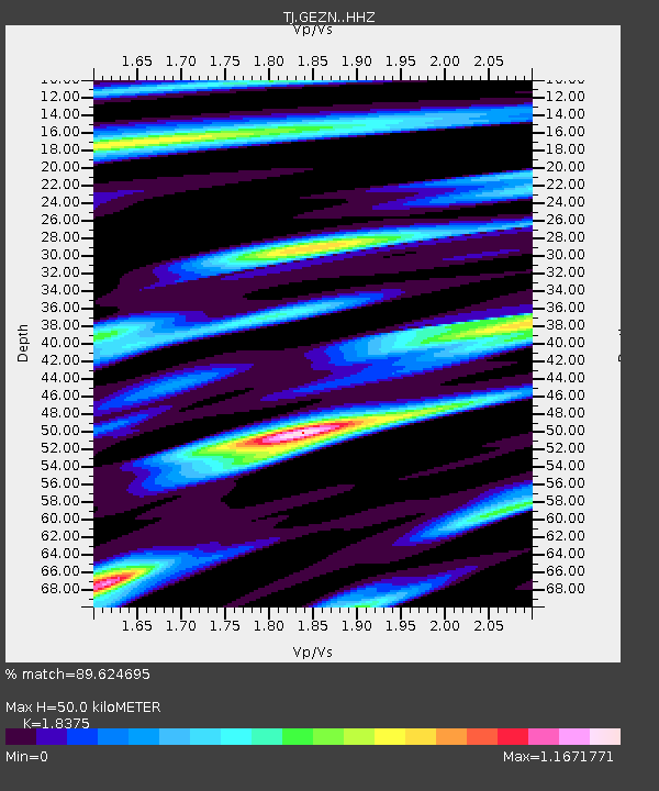
| Estimated Moho Depth: |
50.0 km |
| Estimated Crust Vp/Vs: |
1.84 |
| Assumed Crust Vp: |
6.444 km/s |
| Estimated Crust Vs: |
3.507 km/s |
| Estimated Crust Poisson's Ratio: |
0.29 |
|
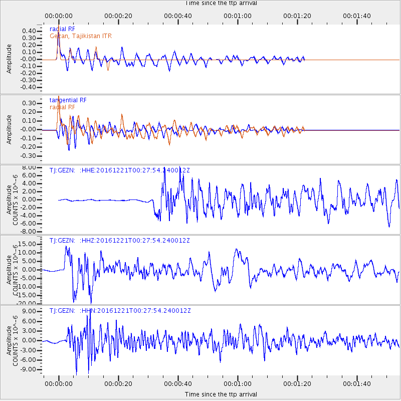
| Radial Match: |
89.624695 % |
| Radial Bump: |
400 |
| Transverse Match: |
83.03258 % |
| Transverse Bump: |
400 |
| SOD ConfigId: |
11737051 |
| Insert Time: |
2019-04-26 10:09:05.810 +0000 |
| GWidth: |
2.5 |
| Max Bumps: |
400 |
| Tol: |
0.001 |
|
Signal To Noise
| Channel | StoN | STA | LTA |
| TJ:GEZN: :HHZ:20161221T00:27:54.240012Z | 34.25429 | 7.0930373E-6 | 2.0707003E-7 |
| TJ:GEZN: :HHN:20161221T00:27:54.240012Z | 5.5312953 | 1.5603647E-6 | 2.8209752E-7 |
| TJ:GEZN: :HHE:20161221T00:27:54.240012Z | 21.871552 | 2.4327333E-6 | 1.112282E-7 |
| Arrivals |
| Ps | 6.7 SECOND |
| PpPs | 21 SECOND |
| PsPs/PpSs | 28 SECOND |


