You are here: Home > Network List > YT07 - POLENET Stations List
> Station FALL FALL > Earthquake Result Viewer
FALL FALL - Earthquake Result Viewer
| Earthquake location: |
Banda Sea |
| Earthquake latitude/longitude: |
-7.5/127.9 |
| Earthquake time(UTC): |
2016/12/21 (356) 00:17:15 GMT |
| Earthquake Depth: |
152 km |
| Earthquake Magnitude: |
6.7 Mww |
| Earthquake Catalog/Contributor: |
NEIC PDE/us |
|
| Network: |
YT POLENET |
| Station: |
FALL FALL |
| Lat/Lon: |
85.31 S/143.63 W |
| Elevation: |
291 m |
|
| Distance: |
82.4 deg |
| Az: |
175.235 deg |
| Baz: |
270.874 deg |
| Ray Param: |
0.04653446 |
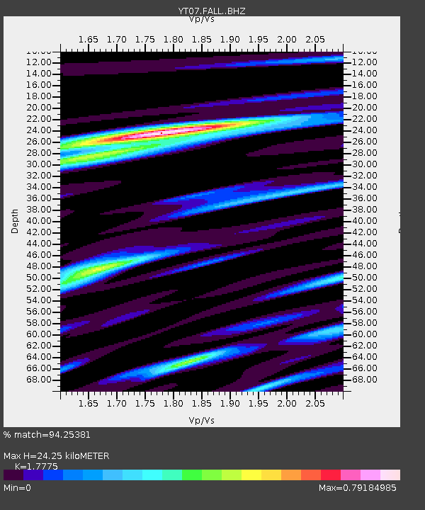
| Estimated Moho Depth: |
24.25 km |
| Estimated Crust Vp/Vs: |
1.78 |
| Assumed Crust Vp: |
6.371 km/s |
| Estimated Crust Vs: |
3.584 km/s |
| Estimated Crust Poisson's Ratio: |
0.27 |
|
| Radial Match: |
94.25381 % |
| Radial Bump: |
369 |
| Transverse Match: |
80.0355 % |
| Transverse Bump: |
400 |
| SOD ConfigId: |
11737051 |
| Insert Time: |
2019-04-26 10:09:36.353 +0000 |
| GWidth: |
2.5 |
| Max Bumps: |
400 |
| Tol: |
0.001 |
|

Signal To Noise
| Channel | StoN | STA | LTA |
| YT:FALL: :BHZ:20161221T00:28:49.17501Z | 12.521594 | 1.5219678E-6 | 1.2154744E-7 |
| YT:FALL: :BHN:20161221T00:28:49.17501Z | 3.2169864 | 4.4656431E-7 | 1.3881449E-7 |
| YT:FALL: :BHE:20161221T00:28:49.17501Z | 9.335125 | 7.243026E-7 | 7.758895E-8 |
| Arrivals |
| Ps | 3.0 SECOND |
| PpPs | 10 SECOND |
| PsPs/PpSs | 13 SECOND |


