You are here: Home > Network List > YT07 - POLENET Stations List
> Station SILY SILY > Earthquake Result Viewer
SILY SILY - Earthquake Result Viewer
| Earthquake location: |
Banda Sea |
| Earthquake latitude/longitude: |
-7.5/127.9 |
| Earthquake time(UTC): |
2016/12/21 (356) 00:17:15 GMT |
| Earthquake Depth: |
152 km |
| Earthquake Magnitude: |
6.7 Mww |
| Earthquake Catalog/Contributor: |
NEIC PDE/us |
|
| Network: |
YT POLENET |
| Station: |
SILY SILY |
| Lat/Lon: |
77.13 S/125.97 W |
| Elevation: |
2093 m |
|
| Distance: |
86.3 deg |
| Az: |
167.543 deg |
| Baz: |
252.617 deg |
| Ray Param: |
0.043815557 |
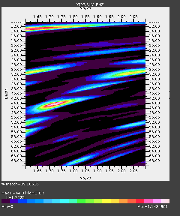
| Estimated Moho Depth: |
44.0 km |
| Estimated Crust Vp/Vs: |
1.72 |
| Assumed Crust Vp: |
6.138 km/s |
| Estimated Crust Vs: |
3.563 km/s |
| Estimated Crust Poisson's Ratio: |
0.25 |
|
| Radial Match: |
89.18526 % |
| Radial Bump: |
400 |
| Transverse Match: |
83.3696 % |
| Transverse Bump: |
400 |
| SOD ConfigId: |
11737051 |
| Insert Time: |
2019-04-26 10:09:47.185 +0000 |
| GWidth: |
2.5 |
| Max Bumps: |
400 |
| Tol: |
0.001 |
|

Signal To Noise
| Channel | StoN | STA | LTA |
| YT:SILY: :BHZ:20161221T00:29:08.448997Z | 7.0791626 | 1.5791217E-6 | 2.2306617E-7 |
| YT:SILY: :BHN:20161221T00:29:08.448997Z | 1.0125096 | 2.726837E-7 | 2.6931468E-7 |
| YT:SILY: :BHE:20161221T00:29:08.448997Z | 1.6671855 | 3.9929597E-7 | 2.39503E-7 |
| Arrivals |
| Ps | 5.3 SECOND |
| PpPs | 19 SECOND |
| PsPs/PpSs | 24 SECOND |


