You are here: Home > Network List > YT07 - POLENET Stations List
> Station RMBO RMBO > Earthquake Result Viewer
RMBO RMBO - Earthquake Result Viewer
| Earthquake location: |
Banda Sea |
| Earthquake latitude/longitude: |
-7.5/127.9 |
| Earthquake time(UTC): |
2016/12/21 (356) 00:17:15 GMT |
| Earthquake Depth: |
152 km |
| Earthquake Magnitude: |
6.7 Mww |
| Earthquake Catalog/Contributor: |
NEIC PDE/us |
|
| Network: |
YT POLENET |
| Station: |
RMBO RMBO |
| Lat/Lon: |
83.87 S/66.40 W |
| Elevation: |
800 m |
|
| Distance: |
88.5 deg |
| Az: |
178.482 deg |
| Baz: |
194.146 deg |
| Ray Param: |
0.042190358 |
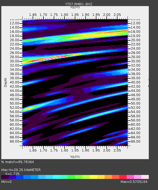
| Estimated Moho Depth: |
28.25 km |
| Estimated Crust Vp/Vs: |
1.74 |
| Assumed Crust Vp: |
6.356 km/s |
| Estimated Crust Vs: |
3.664 km/s |
| Estimated Crust Poisson's Ratio: |
0.25 |
|
| Radial Match: |
95.79364 % |
| Radial Bump: |
389 |
| Transverse Match: |
92.07817 % |
| Transverse Bump: |
396 |
| SOD ConfigId: |
11737051 |
| Insert Time: |
2019-04-26 10:09:47.506 +0000 |
| GWidth: |
2.5 |
| Max Bumps: |
400 |
| Tol: |
0.001 |
|

Signal To Noise
| Channel | StoN | STA | LTA |
| YT:RMBO: :BHZ:20161221T00:29:19.123984Z | 24.948368 | 1.7453942E-6 | 6.996025E-8 |
| YT:RMBO: :BHN:20161221T00:29:19.123984Z | 7.4506974 | 3.558013E-7 | 4.7754092E-8 |
| YT:RMBO: :BHE:20161221T00:29:19.123984Z | 4.9481134 | 3.435955E-7 | 6.94397E-8 |
| Arrivals |
| Ps | 3.3 SECOND |
| PpPs | 12 SECOND |
| PsPs/PpSs | 15 SECOND |


