You are here: Home > Network List > AE - Arizona Broadband Seismic Network Stations List
> Station DUN6 Lazy B Ranch > Earthquake Result Viewer
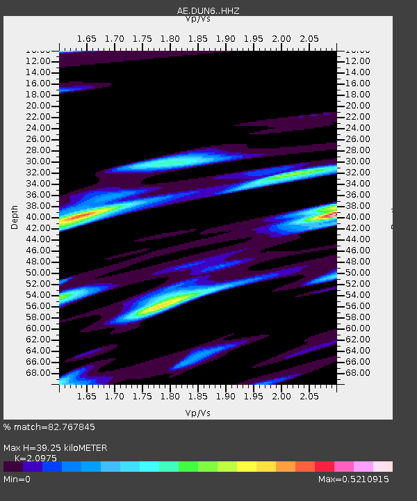
DUN6 Lazy B Ranch - Earthquake Result Viewer
| Earthquake location: |
Mariana Islands Region |
| Earthquake latitude/longitude: |
21.5/145.4 |
| Earthquake time(UTC): |
2016/12/21 (356) 16:43:58 GMT |
| Earthquake Depth: |
17 km |
| Earthquake Magnitude: |
5.9 Mwb |
| Earthquake Catalog/Contributor: |
NEIC PDE/us |
|
| Network: |
AE Arizona Broadband Seismic Network |
| Station: |
DUN6 Lazy B Ranch |
| Lat/Lon: |
32.55 N/109.09 W |
| Elevation: |
1259 m |
|
| Distance: |
90.9 deg |
| Az: |
54.468 deg |
| Baz: |
296.208 deg |
| Ray Param: |
0.041641656 |
| Estimated Moho Depth: |
39.25 km |
| Estimated Crust Vp/Vs: |
2.10 |
| Assumed Crust Vp: |
6.276 km/s |
| Estimated Crust Vs: |
2.992 km/s |
| Estimated Crust Poisson's Ratio: |
0.35 |
|
| Radial Match: |
82.767845 % |
| Radial Bump: |
400 |
| Transverse Match: |
56.345135 % |
| Transverse Bump: |
327 |
| SOD ConfigId: |
11737051 |
| Insert Time: |
2019-04-26 10:11:47.945 +0000 |
| GWidth: |
2.5 |
| Max Bumps: |
400 |
| Tol: |
0.001 |
|

Signal To Noise
| Channel | StoN | STA | LTA |
| AE:DUN6: :HHZ:20161221T16:56:28.929976Z | 7.159412 | 4.436805E-6 | 6.197164E-7 |
| AE:DUN6: :HHN:20161221T16:56:28.929976Z | 2.1378505 | 9.4771116E-7 | 4.4330093E-7 |
| AE:DUN6: :HHE:20161221T16:56:28.929976Z | 2.0279858 | 1.4696097E-6 | 7.246647E-7 |
| Arrivals |
| Ps | 7.0 SECOND |
| PpPs | 19 SECOND |
| PsPs/PpSs | 26 SECOND |


