You are here: Home > Network List > AK - Alaska Regional Network Stations List
> Station MDM Murphy Dome > Earthquake Result Viewer
MDM Murphy Dome - Earthquake Result Viewer
*The percent match for this event was below the threshold and hence no stack was calculated.
| Earthquake location: |
Mariana Islands Region |
| Earthquake latitude/longitude: |
21.5/145.4 |
| Earthquake time(UTC): |
2016/12/21 (356) 16:43:58 GMT |
| Earthquake Depth: |
17 km |
| Earthquake Magnitude: |
5.9 Mwb |
| Earthquake Catalog/Contributor: |
NEIC PDE/us |
|
| Network: |
AK Alaska Regional Network |
| Station: |
MDM Murphy Dome |
| Lat/Lon: |
64.96 N/148.23 W |
| Elevation: |
634 m |
|
| Distance: |
60.7 deg |
| Az: |
26.553 deg |
| Baz: |
257.946 deg |
| Ray Param: |
$rayparam |
*The percent match for this event was below the threshold and hence was not used in the summary stack. |
|
| Radial Match: |
72.62086 % |
| Radial Bump: |
400 |
| Transverse Match: |
65.533195 % |
| Transverse Bump: |
400 |
| SOD ConfigId: |
11737051 |
| Insert Time: |
2019-04-26 10:12:26.366 +0000 |
| GWidth: |
2.5 |
| Max Bumps: |
400 |
| Tol: |
0.001 |
|
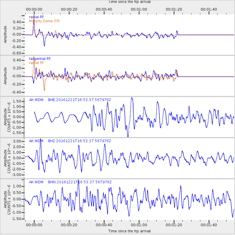
Signal To Noise
| Channel | StoN | STA | LTA |
| AK:MDM: :BHZ:20161221T16:53:37.567976Z | 4.157534 | 1.3965238E-6 | 3.3590192E-7 |
| AK:MDM: :BHN:20161221T16:53:37.567976Z | 1.036893 | 3.1501193E-7 | 3.0380372E-7 |
| AK:MDM: :BHE:20161221T16:53:37.567976Z | 2.0413387 | 5.7310393E-7 | 2.8074908E-7 |
| Arrivals |
| Ps | |
| PpPs | |
| PsPs/PpSs | |


