You are here: Home > Network List > CB - China National Seismic Network Stations List
> Station CD2 Chengdou,Sichuan Province > Earthquake Result Viewer
CD2 Chengdou,Sichuan Province - Earthquake Result Viewer
| Earthquake location: |
Mariana Islands Region |
| Earthquake latitude/longitude: |
21.5/145.4 |
| Earthquake time(UTC): |
2016/12/21 (356) 16:43:58 GMT |
| Earthquake Depth: |
17 km |
| Earthquake Magnitude: |
5.9 Mwb |
| Earthquake Catalog/Contributor: |
NEIC PDE/us |
|
| Network: |
CB China National Seismic Network |
| Station: |
CD2 Chengdou,Sichuan Province |
| Lat/Lon: |
30.91 N/103.76 E |
| Elevation: |
653 m |
|
| Distance: |
38.3 deg |
| Az: |
292.931 deg |
| Baz: |
93.903 deg |
| Ray Param: |
0.07561886 |
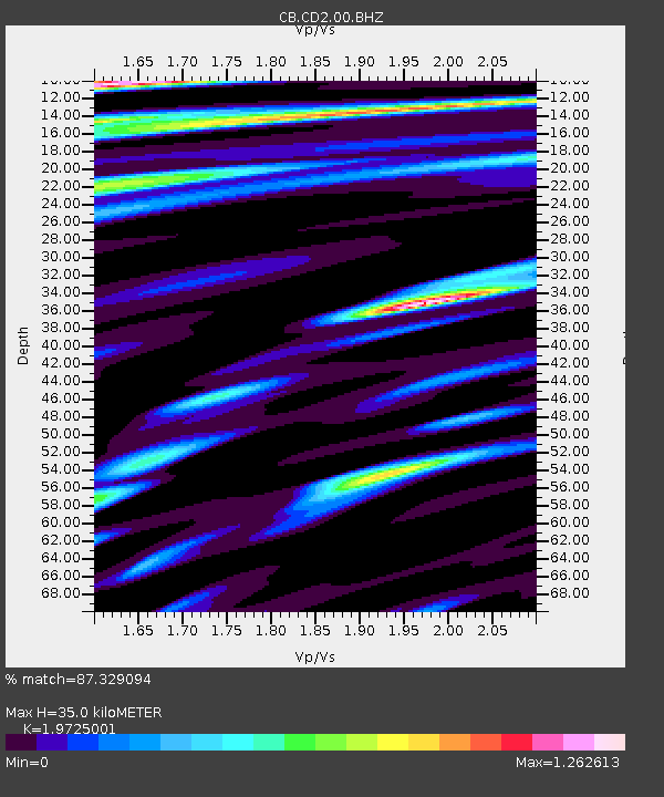
| Estimated Moho Depth: |
35.0 km |
| Estimated Crust Vp/Vs: |
1.97 |
| Assumed Crust Vp: |
6.159 km/s |
| Estimated Crust Vs: |
3.122 km/s |
| Estimated Crust Poisson's Ratio: |
0.33 |
|
| Radial Match: |
87.329094 % |
| Radial Bump: |
400 |
| Transverse Match: |
71.98877 % |
| Transverse Bump: |
400 |
| SOD ConfigId: |
11737051 |
| Insert Time: |
2019-04-26 10:14:09.706 +0000 |
| GWidth: |
2.5 |
| Max Bumps: |
400 |
| Tol: |
0.001 |
|

Signal To Noise
| Channel | StoN | STA | LTA |
| CB:CD2:00:BHZ:20161221T16:50:47.150007Z | 12.6924515 | 2.1906135E-6 | 1.7259184E-7 |
| CB:CD2:00:BHN:20161221T16:50:47.150007Z | 1.6603761 | 2.0729279E-7 | 1.2484689E-7 |
| CB:CD2:00:BHE:20161221T16:50:47.150007Z | 4.680476 | 7.8686594E-7 | 1.6811664E-7 |
| Arrivals |
| Ps | 5.9 SECOND |
| PpPs | 16 SECOND |
| PsPs/PpSs | 22 SECOND |


