You are here: Home > Network List > CI - Caltech Regional Seismic Network Stations List
> Station MPP McPhearson Peak > Earthquake Result Viewer
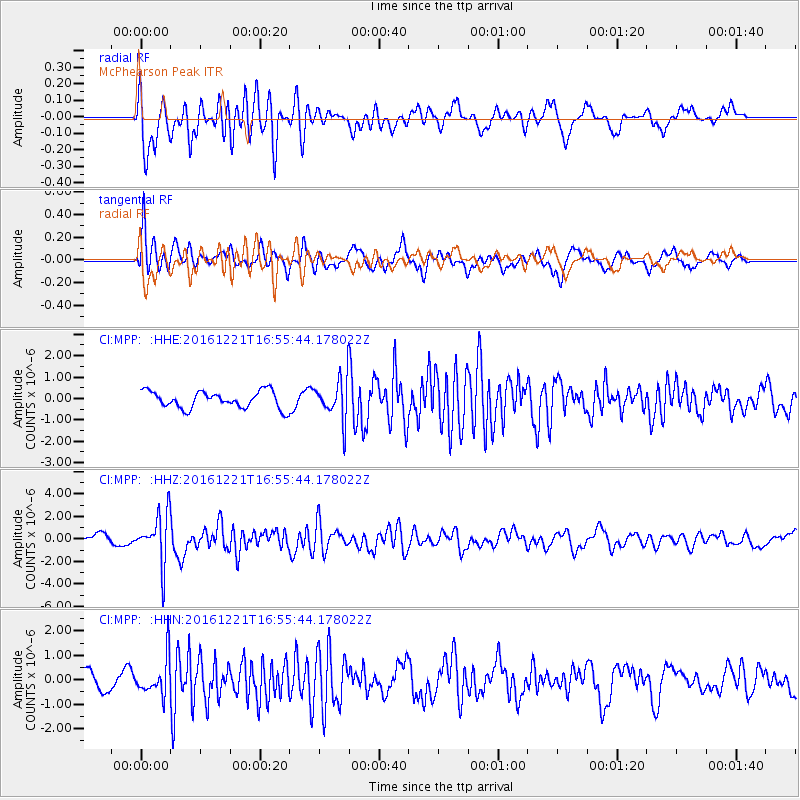
MPP McPhearson Peak - Earthquake Result Viewer
*The percent match for this event was below the threshold and hence no stack was calculated.
| Earthquake location: |
Mariana Islands Region |
| Earthquake latitude/longitude: |
21.5/145.4 |
| Earthquake time(UTC): |
2016/12/21 (356) 16:43:58 GMT |
| Earthquake Depth: |
17 km |
| Earthquake Magnitude: |
5.9 Mwb |
| Earthquake Catalog/Contributor: |
NEIC PDE/us |
|
| Network: |
CI Caltech Regional Seismic Network |
| Station: |
MPP McPhearson Peak |
| Lat/Lon: |
34.89 N/119.81 W |
| Elevation: |
1739 m |
|
| Distance: |
81.7 deg |
| Az: |
55.869 deg |
| Baz: |
290.36 deg |
| Ray Param: |
$rayparam |
*The percent match for this event was below the threshold and hence was not used in the summary stack. |
|
| Radial Match: |
69.26287 % |
| Radial Bump: |
400 |
| Transverse Match: |
66.15435 % |
| Transverse Bump: |
400 |
| SOD ConfigId: |
11737051 |
| Insert Time: |
2019-04-26 10:14:52.202 +0000 |
| GWidth: |
2.5 |
| Max Bumps: |
400 |
| Tol: |
0.001 |
|
Signal To Noise
| Channel | StoN | STA | LTA |
| CI:MPP: :HHZ:20161221T16:55:44.178022Z | 5.2271137 | 2.1928527E-6 | 4.1951498E-7 |
| CI:MPP: :HHN:20161221T16:55:44.178022Z | 1.3165126 | 7.8248513E-7 | 5.94362E-7 |
| CI:MPP: :HHE:20161221T16:55:44.178022Z | 2.713705 | 1.0972332E-6 | 4.0433028E-7 |
| Arrivals |
| Ps | |
| PpPs | |
| PsPs/PpSs | |


