You are here: Home > Network List > CI - Caltech Regional Seismic Network Stations List
> Station TIN Tinemaha, Big Pine, CA, USA > Earthquake Result Viewer
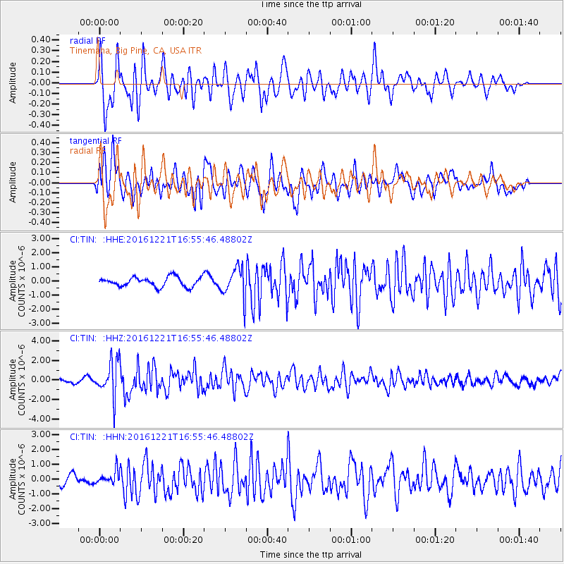
TIN Tinemaha, Big Pine, CA, USA - Earthquake Result Viewer
*The percent match for this event was below the threshold and hence no stack was calculated.
| Earthquake location: |
Mariana Islands Region |
| Earthquake latitude/longitude: |
21.5/145.4 |
| Earthquake time(UTC): |
2016/12/21 (356) 16:43:58 GMT |
| Earthquake Depth: |
17 km |
| Earthquake Magnitude: |
5.9 Mwb |
| Earthquake Catalog/Contributor: |
NEIC PDE/us |
|
| Network: |
CI Caltech Regional Seismic Network |
| Station: |
TIN Tinemaha, Big Pine, CA, USA |
| Lat/Lon: |
37.05 N/118.23 W |
| Elevation: |
1197 m |
|
| Distance: |
82.2 deg |
| Az: |
53.369 deg |
| Baz: |
290.937 deg |
| Ray Param: |
$rayparam |
*The percent match for this event was below the threshold and hence was not used in the summary stack. |
|
| Radial Match: |
77.77899 % |
| Radial Bump: |
400 |
| Transverse Match: |
73.46604 % |
| Transverse Bump: |
400 |
| SOD ConfigId: |
11737051 |
| Insert Time: |
2019-04-26 10:15:11.489 +0000 |
| GWidth: |
2.5 |
| Max Bumps: |
400 |
| Tol: |
0.001 |
|
Signal To Noise
| Channel | StoN | STA | LTA |
| CI:TIN: :HHZ:20161221T16:55:46.48802Z | 8.781961 | 1.8307696E-6 | 2.0846933E-7 |
| CI:TIN: :HHN:20161221T16:55:46.48802Z | 1.0620395 | 4.6184684E-7 | 4.3486784E-7 |
| CI:TIN: :HHE:20161221T16:55:46.48802Z | 3.3031044 | 1.1370736E-6 | 3.4424392E-7 |
| Arrivals |
| Ps | |
| PpPs | |
| PsPs/PpSs | |


