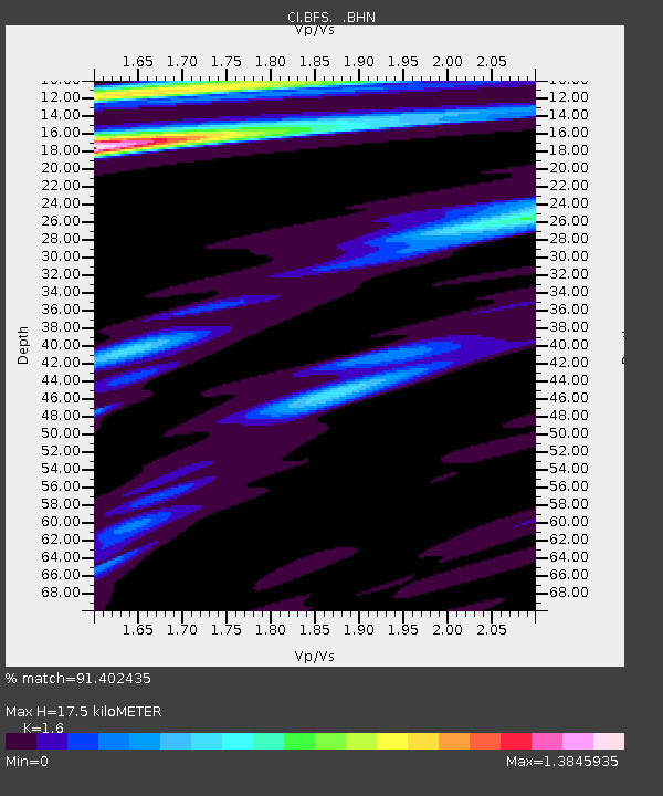
BFS Mt Baldy Forest Station - Earthquake Result Viewer
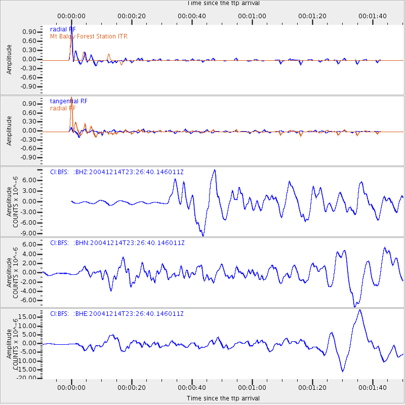
Earthquake location: Caribbean Sea
Earthquake latitude/longitude: 19.0/-81.4
Earthquake time(UTC): 2004/12/14 (349) 23:20:13 GMT
Earthquake Depth: 10 km
Earthquake Magnitude: 6.2 MB, 6.7 MS, 6.8 MW, 6.8 MW
Earthquake Catalog/Contributor: WHDF/NEIC
Network: CI Caltech Regional Seismic Network
Station: BFS Mt Baldy Forest Station
Lat/Lon: 34.24 N/117.66 W
Elevation: 1312 m
Distance: 35.6 deg
Az: 302.685 deg
Baz: 105.949 deg
Ray Param: 0.07713979
Estimated Moho Depth: 17.5 km
Estimated Crust Vp/Vs: 1.60
Assumed Crust Vp: 6.276 km/s
Estimated Crust Vs: 3.922 km/s
Estimated Crust Poisson's Ratio: 0.18
Radial Match: 91.402435 %
Radial Bump: 287
Transverse Match: 82.79859 %
Transverse Bump: 400
SOD ConfigId: 2459
Insert Time: 2010-03-05 20:51:19.251 +0000
GWidth: 2.5
Max Bumps: 400
Tol: 0.001

Signal To Noise

ChannelStoNSTALTA
CI:BFS: :BHN:20041214T23:26:40.146011Z3.02917086.826209E-72.253491E-7
CI:BFS: :BHE:20041214T23:26:40.146011Z5.40565731.4386346E-62.66135E-7
CI:BFS: :BHZ:20041214T23:26:40.146011Z7.8555672.7419799E-63.4904926E-7
Arrivals
Ps1.8 SECOND
PpPs6.7 SECOND
PsPs/PpSs8.5 SECOND