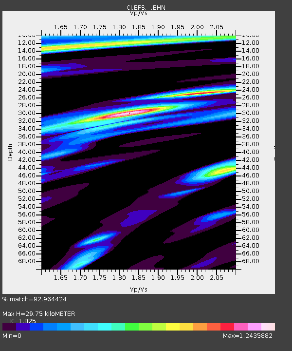
BFS Mt Baldy Forest Station - Earthquake Result Viewer
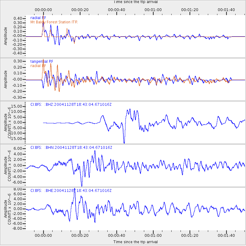
Earthquake location: Hokkaido, Japan Region
Earthquake latitude/longitude: 43.0/145.1
Earthquake time(UTC): 2004/11/28 (333) 18:32:14 GMT
Earthquake Depth: 39 km
Earthquake Magnitude: 6.4 MB, 6.7 MS, 7.0 MW, 7.0 MW
Earthquake Catalog/Contributor: WHDF/NEIC
Network: CI Caltech Regional Seismic Network
Station: BFS Mt Baldy Forest Station
Lat/Lon: 34.24 N/117.66 W
Elevation: 1312 m
Distance: 72.3 deg
Az: 59.629 deg
Baz: 310.186 deg
Ray Param: 0.0536945
Estimated Moho Depth: 29.75 km
Estimated Crust Vp/Vs: 1.83
Assumed Crust Vp: 6.276 km/s
Estimated Crust Vs: 3.439 km/s
Estimated Crust Poisson's Ratio: 0.29
Radial Match: 92.964424 %
Radial Bump: 400
Transverse Match: 83.1119 %
Transverse Bump: 400
SOD ConfigId: 2459
Insert Time: 2010-03-05 20:51:20.708 +0000
GWidth: 2.5
Max Bumps: 400
Tol: 0.001

Signal To Noise

ChannelStoNSTALTA
CI:BFS: :BHN:20041128T18:43:04.671016Z2.04893471.1826771E-65.772156E-7
CI:BFS: :BHE:20041128T18:43:04.671016Z6.1425581.0760734E-61.7518327E-7
CI:BFS: :BHZ:20041128T18:43:04.671016Z9.3657073.5771595E-63.8194227E-7
Arrivals
Ps4.0 SECOND
PpPs13 SECOND
PsPs/PpSs17 SECOND