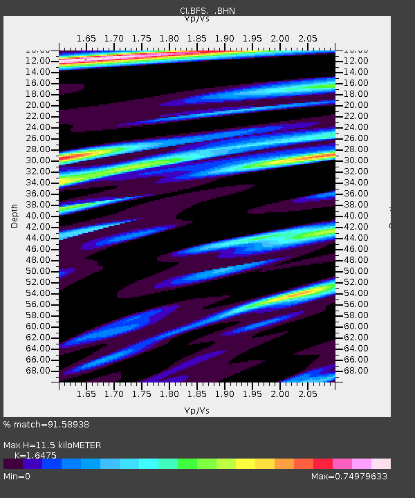
BFS Mt Baldy Forest Station - Earthquake Result Viewer

Earthquake location: Santiago Del Estero Prov., Arg.
Earthquake latitude/longitude: -28.6/-65.8
Earthquake time(UTC): 2004/09/07 (251) 11:53:06 GMT
Earthquake Depth: 22 km
Earthquake Magnitude: 6.1 MB, 6.1 MS, 6.4 MW, 6.2 MW
Earthquake Catalog/Contributor: WHDF/NEIC
Network: CI Caltech Regional Seismic Network
Station: BFS Mt Baldy Forest Station
Lat/Lon: 34.24 N/117.66 W
Elevation: 1312 m
Distance: 79.4 deg
Az: 318.508 deg
Baz: 135.301 deg
Ray Param: 0.04896363
Estimated Moho Depth: 11.5 km
Estimated Crust Vp/Vs: 1.65
Assumed Crust Vp: 6.276 km/s
Estimated Crust Vs: 3.809 km/s
Estimated Crust Poisson's Ratio: 0.21
Radial Match: 91.58938 %
Radial Bump: 400
Transverse Match: 81.286194 %
Transverse Bump: 400
SOD ConfigId: 2459
Insert Time: 2010-03-05 20:51:23.867 +0000
GWidth: 2.5
Max Bumps: 400
Tol: 0.001

Signal To Noise

ChannelStoNSTALTA
CI:BFS: :BHN:20040907T12:04:39.044998Z4.4584855.5334317E-71.2411013E-7
CI:BFS: :BHE:20040907T12:04:39.044998Z5.59579236.4300355E-71.149084E-7
CI:BFS: :BHZ:20040907T12:04:39.044998Z15.1539152.4178244E-61.5955113E-7
Arrivals
Ps1.2 SECOND
PpPs4.7 SECOND
PsPs/PpSs5.9 SECOND