You are here: Home > Network List > TA - USArray Transportable Network (new EarthScope stations) Stations List
> Station F21K Alatna River, AK, USA > Earthquake Result Viewer
F21K Alatna River, AK, USA - Earthquake Result Viewer

| Earthquake location: |
Mariana Islands Region |
| Earthquake latitude/longitude: |
21.5/145.4 |
| Earthquake time(UTC): |
2016/12/21 (356) 16:43:58 GMT |
| Earthquake Depth: |
17 km |
| Earthquake Magnitude: |
5.9 Mwb |
| Earthquake Catalog/Contributor: |
NEIC PDE/us |
|
| Network: |
TA USArray Transportable Network (new EarthScope stations) |
| Station: |
F21K Alatna River, AK, USA |
| Lat/Lon: |
67.22 N/153.48 W |
| Elevation: |
597 m |
|
| Distance: |
59.3 deg |
| Az: |
23.373 deg |
| Baz: |
251.556 deg |
| Ray Param: |
0.062285736 |
| Estimated Moho Depth: |
32.25 km |
| Estimated Crust Vp/Vs: |
1.93 |
| Assumed Crust Vp: |
6.455 km/s |
| Estimated Crust Vs: |
3.345 km/s |
| Estimated Crust Poisson's Ratio: |
0.32 |
|
| Radial Match: |
85.06919 % |
| Radial Bump: |
400 |
| Transverse Match: |
73.29602 % |
| Transverse Bump: |
400 |
| SOD ConfigId: |
11737051 |
| Insert Time: |
2019-04-26 10:19:40.276 +0000 |
| GWidth: |
2.5 |
| Max Bumps: |
400 |
| Tol: |
0.001 |
|
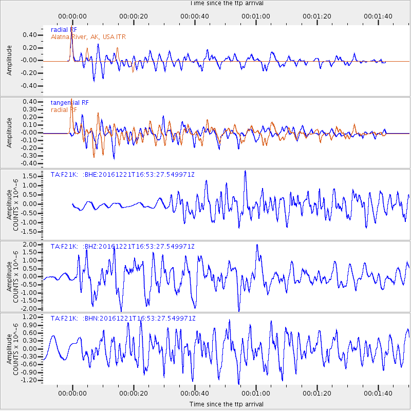
Signal To Noise
| Channel | StoN | STA | LTA |
| TA:F21K: :BHZ:20161221T16:53:27.549971Z | 3.7456353 | 7.175123E-7 | 1.9155958E-7 |
| TA:F21K: :BHN:20161221T16:53:27.549971Z | 1.3224468 | 2.8384576E-7 | 2.146368E-7 |
| TA:F21K: :BHE:20161221T16:53:27.549971Z | 2.8183599 | 3.3112696E-7 | 1.1748924E-7 |
| Arrivals |
| Ps | 4.9 SECOND |
| PpPs | 14 SECOND |
| PsPs/PpSs | 19 SECOND |


