You are here: Home > Network List > TA - USArray Transportable Network (new EarthScope stations) Stations List
> Station M31M Drury Creek, Yukon, CA > Earthquake Result Viewer
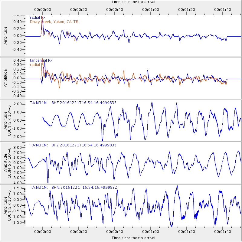
M31M Drury Creek, Yukon, CA - Earthquake Result Viewer
*The percent match for this event was below the threshold and hence no stack was calculated.
| Earthquake location: |
Mariana Islands Region |
| Earthquake latitude/longitude: |
21.5/145.4 |
| Earthquake time(UTC): |
2016/12/21 (356) 16:43:58 GMT |
| Earthquake Depth: |
17 km |
| Earthquake Magnitude: |
5.9 Mwb |
| Earthquake Catalog/Contributor: |
NEIC PDE/us |
|
| Network: |
TA USArray Transportable Network (new EarthScope stations) |
| Station: |
M31M Drury Creek, Yukon, CA |
| Lat/Lon: |
62.20 N/134.39 W |
| Elevation: |
639 m |
|
| Distance: |
66.7 deg |
| Az: |
30.213 deg |
| Baz: |
271.962 deg |
| Ray Param: |
$rayparam |
*The percent match for this event was below the threshold and hence was not used in the summary stack. |
|
| Radial Match: |
50.957653 % |
| Radial Bump: |
400 |
| Transverse Match: |
76.373276 % |
| Transverse Bump: |
400 |
| SOD ConfigId: |
11737051 |
| Insert Time: |
2019-04-26 10:20:11.297 +0000 |
| GWidth: |
2.5 |
| Max Bumps: |
400 |
| Tol: |
0.001 |
|
Signal To Noise
| Channel | StoN | STA | LTA |
| TA:M31M: :BHZ:20161221T16:54:16.499983Z | 1.8938246 | 1.399375E-6 | 7.389148E-7 |
| TA:M31M: :BHN:20161221T16:54:16.499983Z | 0.99435127 | 5.8146264E-7 | 5.847658E-7 |
| TA:M31M: :BHE:20161221T16:54:16.499983Z | 1.7650696 | 1.0340983E-6 | 5.8586824E-7 |
| Arrivals |
| Ps | |
| PpPs | |
| PsPs/PpSs | |


