You are here: Home > Network List > TA - USArray Transportable Network (new EarthScope stations) Stations List
> Station O17K Koliganek, Bristol Bay, AK, USA > Earthquake Result Viewer
O17K Koliganek, Bristol Bay, AK, USA - Earthquake Result Viewer

| Earthquake location: |
Mariana Islands Region |
| Earthquake latitude/longitude: |
21.5/145.4 |
| Earthquake time(UTC): |
2016/12/21 (356) 16:43:58 GMT |
| Earthquake Depth: |
17 km |
| Earthquake Magnitude: |
5.9 Mwb |
| Earthquake Catalog/Contributor: |
NEIC PDE/us |
|
| Network: |
TA USArray Transportable Network (new EarthScope stations) |
| Station: |
O17K Koliganek, Bristol Bay, AK, USA |
| Lat/Lon: |
59.77 N/157.09 W |
| Elevation: |
156 m |
|
| Distance: |
55.4 deg |
| Az: |
31.228 deg |
| Baz: |
252.567 deg |
| Ray Param: |
0.06479163 |
| Estimated Moho Depth: |
19.25 km |
| Estimated Crust Vp/Vs: |
2.09 |
| Assumed Crust Vp: |
6.276 km/s |
| Estimated Crust Vs: |
3.003 km/s |
| Estimated Crust Poisson's Ratio: |
0.35 |
|
| Radial Match: |
80.35779 % |
| Radial Bump: |
400 |
| Transverse Match: |
73.62646 % |
| Transverse Bump: |
400 |
| SOD ConfigId: |
11737051 |
| Insert Time: |
2019-04-26 10:20:20.107 +0000 |
| GWidth: |
2.5 |
| Max Bumps: |
400 |
| Tol: |
0.001 |
|
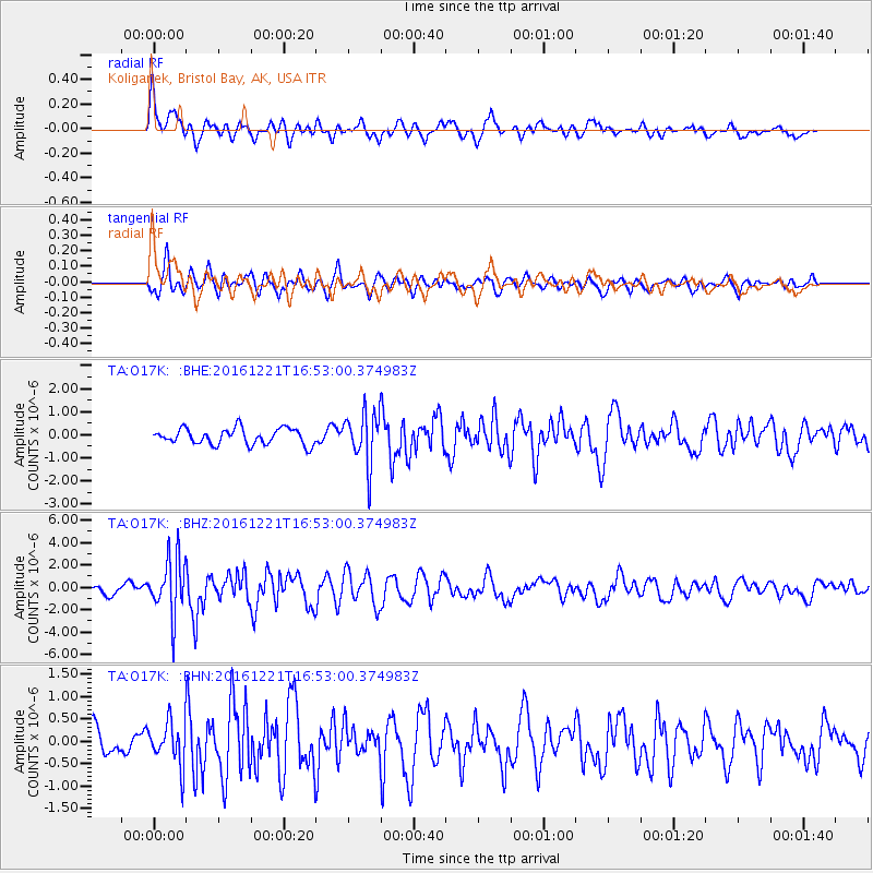
Signal To Noise
| Channel | StoN | STA | LTA |
| TA:O17K: :BHZ:20161221T16:53:00.374983Z | 5.698593 | 2.5748323E-6 | 4.5183646E-7 |
| TA:O17K: :BHN:20161221T16:53:00.374983Z | 1.8873068 | 4.8115226E-7 | 2.549412E-7 |
| TA:O17K: :BHE:20161221T16:53:00.374983Z | 3.3484364 | 1.1621554E-6 | 3.4707406E-7 |
| Arrivals |
| Ps | 3.5 SECOND |
| PpPs | 9.1 SECOND |
| PsPs/PpSs | 13 SECOND |


