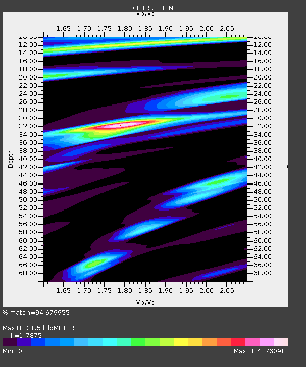
BFS Mt Baldy Forest Station - Earthquake Result Viewer

Earthquake location: Off East Coast Of Honshu, Japan
Earthquake latitude/longitude: 38.1/144.9
Earthquake time(UTC): 2005/11/14 (318) 21:38:51 GMT
Earthquake Depth: 11 km
Earthquake Magnitude: 6.7 MB, 6.8 MS, 7.0 MW, 6.9 MW
Earthquake Catalog/Contributor: WHDF/NEIC
Network: CI Caltech Regional Seismic Network
Station: BFS Mt Baldy Forest Station
Lat/Lon: 34.24 N/117.66 W
Elevation: 1312 m
Distance: 75.0 deg
Az: 58.278 deg
Baz: 305.908 deg
Ray Param: 0.0519814
Estimated Moho Depth: 31.5 km
Estimated Crust Vp/Vs: 1.79
Assumed Crust Vp: 6.276 km/s
Estimated Crust Vs: 3.511 km/s
Estimated Crust Poisson's Ratio: 0.27
Radial Match: 94.679955 %
Radial Bump: 400
Transverse Match: 88.5693 %
Transverse Bump: 400
SOD ConfigId: 2448
Insert Time: 2010-03-05 20:52:03.487 +0000
GWidth: 2.5
Max Bumps: 400
Tol: 0.001

Signal To Noise

ChannelStoNSTALTA
CI:BFS: :BHN:20051114T21:50:01.162004Z2.34649593.9367097E-71.6776973E-7
CI:BFS: :BHE:20051114T21:50:01.162004Z3.6226875.757192E-71.5892049E-7
CI:BFS: :BHZ:20051114T21:50:01.162004Z8.0064741.8715332E-62.337525E-7
Arrivals
Ps4.1 SECOND
PpPs14 SECOND
PsPs/PpSs18 SECOND