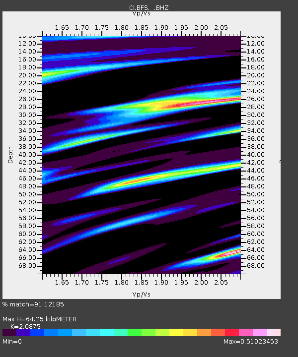
BFS Mt Baldy Forest Station - Earthquake Result Viewer

Earthquake location: Tonga Islands
Earthquake latitude/longitude: -21.9/-173.8
Earthquake time(UTC): 2008/10/19 (293) 05:10:33 GMT
Earthquake Depth: 29 km
Earthquake Magnitude: 6.8 MB, 7.0 MS, 6.9 MW, 6.9 MW
Earthquake Catalog/Contributor: WHDF/NEIC
Network: CI Caltech Regional Seismic Network
Station: BFS Mt Baldy Forest Station
Lat/Lon: 34.24 N/117.66 W
Elevation: 1312 m
Distance: 77.2 deg
Az: 44.877 deg
Baz: 232.295 deg
Ray Param: 0.050431997
Estimated Moho Depth: 64.25 km
Estimated Crust Vp/Vs: 2.09
Assumed Crust Vp: 6.276 km/s
Estimated Crust Vs: 3.006 km/s
Estimated Crust Poisson's Ratio: 0.35
Radial Match: 91.12185 %
Radial Bump: 331
Transverse Match: 78.02925 %
Transverse Bump: 400
SOD ConfigId: 2556
Insert Time: 2010-03-05 20:52:49.228 +0000
GWidth: 2.5
Max Bumps: 400
Tol: 0.001

Signal To Noise

ChannelStoNSTALTA
CI:BFS: :BHZ:20081019T05:21:53.985012Z35.0828327.0686638E-62.01485E-7
CI:BFS: :BHN:20081019T05:21:53.985012Z21.911151.9059219E-68.698411E-8
CI:BFS: :BHE:20081019T05:21:53.985012Z20.3259831.9716688E-69.7002385E-8
Arrivals
Ps11 SECOND
PpPs31 SECOND
PsPs/PpSs42 SECOND