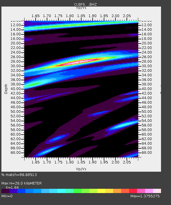
BFS Mt Baldy Forest Station - Earthquake Result Viewer

Earthquake location: East Of Kuril Islands
Earthquake latitude/longitude: 46.9/155.2
Earthquake time(UTC): 2009/01/15 (015) 17:49:39 GMT
Earthquake Depth: 36 km
Earthquake Magnitude: 6.9 MB, 7.5 MS, 7.4 MW, 7.4 MW
Earthquake Catalog/Contributor: WHDF/NEIC
Network: CI Caltech Regional Seismic Network
Station: BFS Mt Baldy Forest Station
Lat/Lon: 34.24 N/117.66 W
Elevation: 1312 m
Distance: 64.2 deg
Az: 66.792 deg
Baz: 310.418 deg
Ray Param: 0.05901499
Estimated Moho Depth: 28.0 km
Estimated Crust Vp/Vs: 1.84
Assumed Crust Vp: 6.276 km/s
Estimated Crust Vs: 3.411 km/s
Estimated Crust Poisson's Ratio: 0.29
Radial Match: 96.68513 %
Radial Bump: 365
Transverse Match: 88.2131 %
Transverse Bump: 400
SOD ConfigId: 2834
Insert Time: 2010-03-05 20:52:54.561 +0000
GWidth: 2.5
Max Bumps: 400
Tol: 0.001

Signal To Noise

ChannelStoNSTALTA
CI:BFS: :BHZ:20090115T17:59:39.410027Z46.4989361.0512016E-52.2607003E-7
CI:BFS: :BHN:20090115T17:59:39.410027Z10.0200082.9978137E-62.9918277E-7
CI:BFS: :BHE:20090115T17:59:39.410027Z24.3563753.636077E-61.4928646E-7
Arrivals
Ps3.9 SECOND
PpPs12 SECOND
PsPs/PpSs16 SECOND