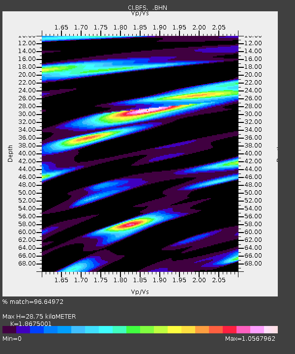
BFS Mt Baldy Forest Station - Earthquake Result Viewer

Earthquake location: Solomon Islands
Earthquake latitude/longitude: -8.5/157.0
Earthquake time(UTC): 2007/04/01 (091) 20:39:56 GMT
Earthquake Depth: 10 km
Earthquake Magnitude: 6.8 MB, 7.9 MS, 8.1 MW, 7.7 ME
Earthquake Catalog/Contributor: WHDF/NEIC
Network: CI Caltech Regional Seismic Network
Station: BFS Mt Baldy Forest Station
Lat/Lon: 34.24 N/117.66 W
Elevation: 1312 m
Distance: 90.8 deg
Az: 55.665 deg
Baz: 260.414 deg
Ray Param: 0.041644678
Estimated Moho Depth: 28.75 km
Estimated Crust Vp/Vs: 1.87
Assumed Crust Vp: 6.276 km/s
Estimated Crust Vs: 3.361 km/s
Estimated Crust Poisson's Ratio: 0.30
Radial Match: 96.64972 %
Radial Bump: 400
Transverse Match: 91.515495 %
Transverse Bump: 400
SOD ConfigId: 2564
Insert Time: 2010-03-05 20:53:38.531 +0000
GWidth: 2.5
Max Bumps: 400
Tol: 0.001

Signal To Noise

ChannelStoNSTALTA
CI:BFS: :BHN:20070401T20:52:28.293025Z1.44082092.6794487E-71.8596681E-7
CI:BFS: :BHE:20070401T20:52:28.293025Z2.84341764.3893337E-71.5436824E-7
CI:BFS: :BHZ:20070401T20:52:28.293025Z7.9085221.4641497E-61.851357E-7
Arrivals
Ps4.0 SECOND
PpPs13 SECOND
PsPs/PpSs17 SECOND