You are here: Home > Network List > YT07 - POLENET Stations List
> Station FALL FALL > Earthquake Result Viewer
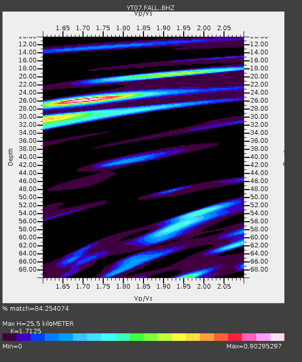
FALL FALL - Earthquake Result Viewer
| Earthquake location: |
New Ireland Region, P.N.G. |
| Earthquake latitude/longitude: |
-5.1/153.5 |
| Earthquake time(UTC): |
2016/12/24 (359) 03:58:55 GMT |
| Earthquake Depth: |
32 km |
| Earthquake Magnitude: |
5.8 mb |
| Earthquake Catalog/Contributor: |
NEIC PDE/us |
|
| Network: |
YT POLENET |
| Station: |
FALL FALL |
| Lat/Lon: |
85.31 S/143.63 W |
| Elevation: |
291 m |
|
| Distance: |
82.8 deg |
| Az: |
175.762 deg |
| Baz: |
296.676 deg |
| Ray Param: |
0.046615496 |
| Estimated Moho Depth: |
25.5 km |
| Estimated Crust Vp/Vs: |
1.71 |
| Assumed Crust Vp: |
6.371 km/s |
| Estimated Crust Vs: |
3.72 km/s |
| Estimated Crust Poisson's Ratio: |
0.24 |
|
| Radial Match: |
84.254074 % |
| Radial Bump: |
400 |
| Transverse Match: |
32.084965 % |
| Transverse Bump: |
400 |
| SOD ConfigId: |
11737051 |
| Insert Time: |
2019-04-26 10:34:17.560 +0000 |
| GWidth: |
2.5 |
| Max Bumps: |
400 |
| Tol: |
0.001 |
|

Signal To Noise
| Channel | StoN | STA | LTA |
| YT:FALL: :BHZ:20161224T04:10:44.450015Z | 10.890265 | 9.4489377E-7 | 8.6764985E-8 |
| YT:FALL: :BHN:20161224T04:10:44.450015Z | 1.6743268 | 3.0734628E-7 | 1.835641E-7 |
| YT:FALL: :BHE:20161224T04:10:44.450015Z | 3.9344447 | 4.1207795E-7 | 1.04735996E-7 |
| Arrivals |
| Ps | 2.9 SECOND |
| PpPs | 11 SECOND |
| PsPs/PpSs | 14 SECOND |


