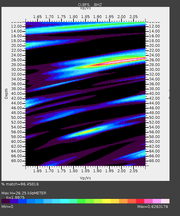
BFS Mt Baldy Forest Station - Earthquake Result Viewer

Earthquake location: Tonga Islands Region
Earthquake latitude/longitude: -23.0/-174.7
Earthquake time(UTC): 2009/03/19 (078) 18:17:40 GMT
Earthquake Depth: 34 km
Earthquake Magnitude: 7.0 MB, 7.6 MS, 7.6 MW, 7.6 MW
Earthquake Catalog/Contributor: WHDF/NEIC
Network: CI Caltech Regional Seismic Network
Station: BFS Mt Baldy Forest Station
Lat/Lon: 34.24 N/117.66 W
Elevation: 1312 m
Distance: 78.6 deg
Az: 45.136 deg
Baz: 232.006 deg
Ray Param: 0.04948196
Estimated Moho Depth: 26.25 km
Estimated Crust Vp/Vs: 2.00
Assumed Crust Vp: 6.276 km/s
Estimated Crust Vs: 3.142 km/s
Estimated Crust Poisson's Ratio: 0.33
Radial Match: 96.45816 %
Radial Bump: 386
Transverse Match: 83.185234 %
Transverse Bump: 400
SOD ConfigId: 2658
Insert Time: 2010-03-05 20:54:25.178 +0000
GWidth: 2.5
Max Bumps: 400
Tol: 0.001

Signal To Noise

ChannelStoNSTALTA
CI:BFS: :BHZ:20090319T18:29:08.086025Z19.9704426.2833537E-63.146327E-7
CI:BFS: :BHN:20090319T18:29:08.086025Z4.87823531.5628198E-63.203658E-7
CI:BFS: :BHE:20090319T18:29:08.086025Z9.3372321.635157E-61.7512225E-7
Arrivals
Ps4.3 SECOND
PpPs12 SECOND
PsPs/PpSs17 SECOND