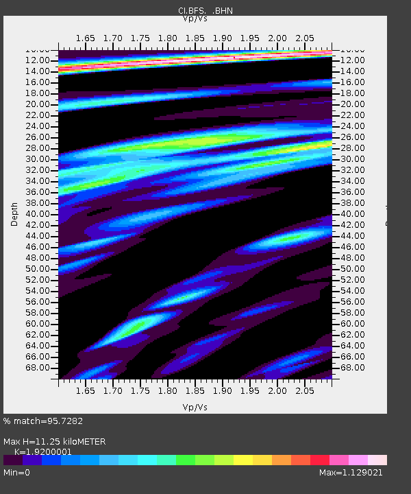
BFS Mt Baldy Forest Station - Earthquake Result Viewer
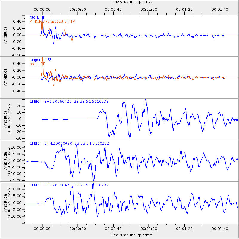
Earthquake location: Eastern Siberia, Russia
Earthquake latitude/longitude: 60.9/167.1
Earthquake time(UTC): 2006/04/20 (110) 23:25:02 GMT
Earthquake Depth: 22 km
Earthquake Magnitude: 6.8 MB, 7.6 MS, 7.6 MW, 7.3 MW
Earthquake Catalog/Contributor: WHDF/NEIC
Network: CI Caltech Regional Seismic Network
Station: BFS Mt Baldy Forest Station
Lat/Lon: 34.24 N/117.66 W
Elevation: 1312 m
Distance: 53.7 deg
Az: 83.64 deg
Baz: 324.16 deg
Ray Param: 0.06588107
Estimated Moho Depth: 11.25 km
Estimated Crust Vp/Vs: 1.92
Assumed Crust Vp: 6.276 km/s
Estimated Crust Vs: 3.269 km/s
Estimated Crust Poisson's Ratio: 0.31
Radial Match: 95.7282 %
Radial Bump: 400
Transverse Match: 89.56602 %
Transverse Bump: 400
SOD ConfigId: 2669
Insert Time: 2010-03-05 20:54:55.530 +0000
GWidth: 2.5
Max Bumps: 400
Tol: 0.001

Signal To Noise

ChannelStoNSTALTA
CI:BFS: :BHN:20060420T23:33:51.511023Z20.7240963.3572803E-61.6199887E-7
CI:BFS: :BHE:20060420T23:33:51.511023Z27.4937082.622556E-69.538749E-8
CI:BFS: :BHZ:20060420T23:33:51.511023Z44.6179928.7571125E-61.9626863E-7
Arrivals
Ps1.7 SECOND
PpPs5.0 SECOND
PsPs/PpSs6.7 SECOND