You are here: Home > Network List > CI - Caltech Regional Seismic Network Stations List
> Station BFS Mt Baldy Forest Station > Earthquake Result Viewer
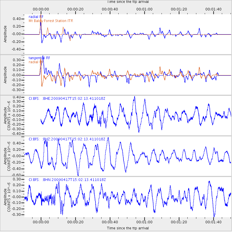
BFS Mt Baldy Forest Station - Earthquake Result Viewer
*The percent match for this event was below the threshold and hence no stack was calculated.
| Earthquake location: |
Kuril Islands |
| Earthquake latitude/longitude: |
46.2/151.7 |
| Earthquake time(UTC): |
2009/04/17 (107) 14:51:58 GMT |
| Earthquake Depth: |
49 km |
| Earthquake Magnitude: |
5.5 MB, 5.0 MS, 5.7 MW, 5.6 MW |
| Earthquake Catalog/Contributor: |
WHDF/NEIC |
|
| Network: |
CI Caltech Regional Seismic Network |
| Station: |
BFS Mt Baldy Forest Station |
| Lat/Lon: |
34.24 N/117.66 W |
| Elevation: |
1312 m |
|
| Distance: |
66.7 deg |
| Az: |
64.459 deg |
| Baz: |
310.809 deg |
| Ray Param: |
$rayparam |
*The percent match for this event was below the threshold and hence was not used in the summary stack. |
|
| Radial Match: |
65.74804 % |
| Radial Bump: |
400 |
| Transverse Match: |
55.742893 % |
| Transverse Bump: |
400 |
| SOD ConfigId: |
2658 |
| Insert Time: |
2010-03-05 20:56:08.038 +0000 |
| GWidth: |
2.5 |
| Max Bumps: |
400 |
| Tol: |
0.001 |
|
Signal To Noise
| Channel | StoN | STA | LTA |
| CI:BFS: :BHZ:20090417T15:02:13.411018Z | 2.5990214 | 3.1238494E-7 | 1.201933E-7 |
| CI:BFS: :BHN:20090417T15:02:13.411018Z | 0.381374 | 5.5539786E-8 | 1.4563076E-7 |
| CI:BFS: :BHE:20090417T15:02:13.411018Z | 1.2064736 | 1.3542292E-7 | 1.122469E-7 |
| Arrivals |
| Ps | |
| PpPs | |
| PsPs/PpSs | |


