You are here: Home > Network List > UW - Pacific Northwest Regional Seismic Network Stations List
> Station HOOD Mt Hood Meadows, OR CREST BB SMO > Earthquake Result Viewer
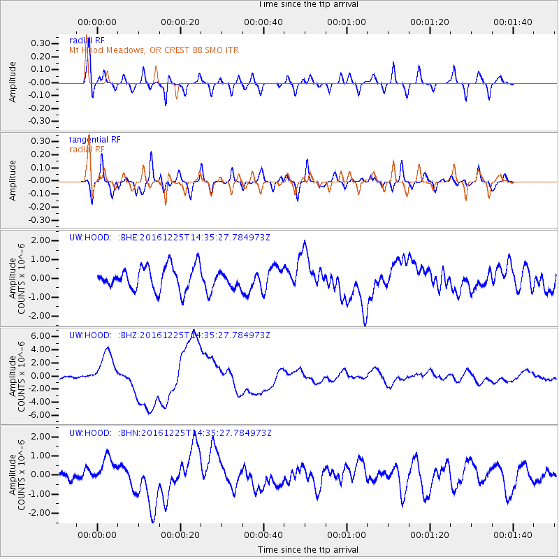
HOOD Mt Hood Meadows, OR CREST BB SMO - Earthquake Result Viewer
*The percent match for this event was below the threshold and hence no stack was calculated.
| Earthquake location: |
Southern Chile |
| Earthquake latitude/longitude: |
-43.3/-74.5 |
| Earthquake time(UTC): |
2016/12/25 (360) 14:22:28 GMT |
| Earthquake Depth: |
15 km |
| Earthquake Magnitude: |
7.7 Mi |
| Earthquake Catalog/Contributor: |
NEIC PDE/at |
|
| Network: |
UW Pacific Northwest Regional Seismic Network |
| Station: |
HOOD Mt Hood Meadows, OR CREST BB SMO |
| Lat/Lon: |
45.32 N/121.65 W |
| Elevation: |
1520 m |
|
| Distance: |
97.7 deg |
| Az: |
328.535 deg |
| Baz: |
147.307 deg |
| Ray Param: |
$rayparam |
*The percent match for this event was below the threshold and hence was not used in the summary stack. |
|
| Radial Match: |
84.94528 % |
| Radial Bump: |
400 |
| Transverse Match: |
64.98826 % |
| Transverse Bump: |
400 |
| SOD ConfigId: |
11737051 |
| Insert Time: |
2019-04-26 10:45:50.738 +0000 |
| GWidth: |
2.5 |
| Max Bumps: |
400 |
| Tol: |
0.001 |
|
Signal To Noise
| Channel | StoN | STA | LTA |
| UW:HOOD: :BHZ:20161225T14:35:27.784973Z | 8.046845 | 2.7692925E-6 | 3.4414634E-7 |
| UW:HOOD: :BHN:20161225T14:35:27.784973Z | 1.5451741 | 7.286258E-7 | 4.7154936E-7 |
| UW:HOOD: :BHE:20161225T14:35:27.784973Z | 0.9434065 | 6.212399E-7 | 6.5850713E-7 |
| Arrivals |
| Ps | |
| PpPs | |
| PsPs/PpSs | |


