You are here: Home > Network List > CI - Caltech Regional Seismic Network Stations List
> Station BFS Mt Baldy Forest Station > Earthquake Result Viewer
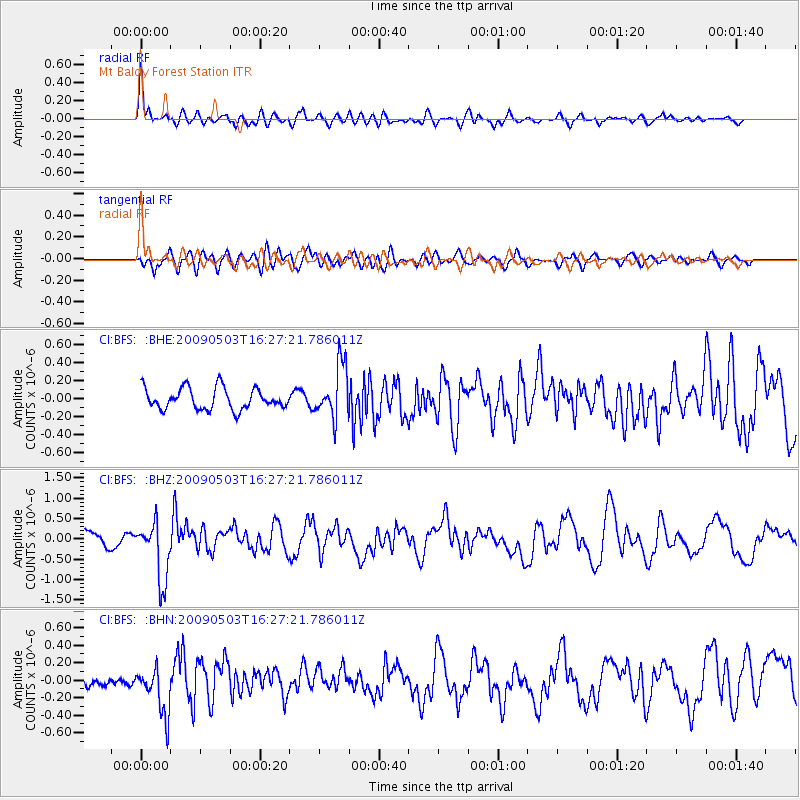
BFS Mt Baldy Forest Station - Earthquake Result Viewer
*The percent match for this event was below the threshold and hence no stack was calculated.
| Earthquake location: |
Guatemala |
| Earthquake latitude/longitude: |
14.6/-91.2 |
| Earthquake time(UTC): |
2009/05/03 (123) 16:21:47 GMT |
| Earthquake Depth: |
124 km |
| Earthquake Magnitude: |
5.6 MB, 6.2 MW, 6.2 MW |
| Earthquake Catalog/Contributor: |
WHDF/NEIC |
|
| Network: |
CI Caltech Regional Seismic Network |
| Station: |
BFS Mt Baldy Forest Station |
| Lat/Lon: |
34.24 N/117.66 W |
| Elevation: |
1312 m |
|
| Distance: |
30.9 deg |
| Az: |
314.005 deg |
| Baz: |
122.792 deg |
| Ray Param: |
$rayparam |
*The percent match for this event was below the threshold and hence was not used in the summary stack. |
|
| Radial Match: |
77.977325 % |
| Radial Bump: |
400 |
| Transverse Match: |
55.960255 % |
| Transverse Bump: |
400 |
| SOD ConfigId: |
2658 |
| Insert Time: |
2010-03-05 20:57:01.297 +0000 |
| GWidth: |
2.5 |
| Max Bumps: |
400 |
| Tol: |
0.001 |
|
Signal To Noise
| Channel | StoN | STA | LTA |
| CI:BFS: :BHZ:20090503T16:27:21.786011Z | 4.9480004 | 7.227272E-7 | 1.460645E-7 |
| CI:BFS: :BHN:20090503T16:27:21.786011Z | 2.9155664 | 2.622544E-7 | 8.9949715E-8 |
| CI:BFS: :BHE:20090503T16:27:21.786011Z | 2.519587 | 2.9335135E-7 | 1.1642834E-7 |
| Arrivals |
| Ps | |
| PpPs | |
| PsPs/PpSs | |


