You are here: Home > Network List > CI - Caltech Regional Seismic Network Stations List
> Station MPM Manuel Prospect Mine, California, USA > Earthquake Result Viewer
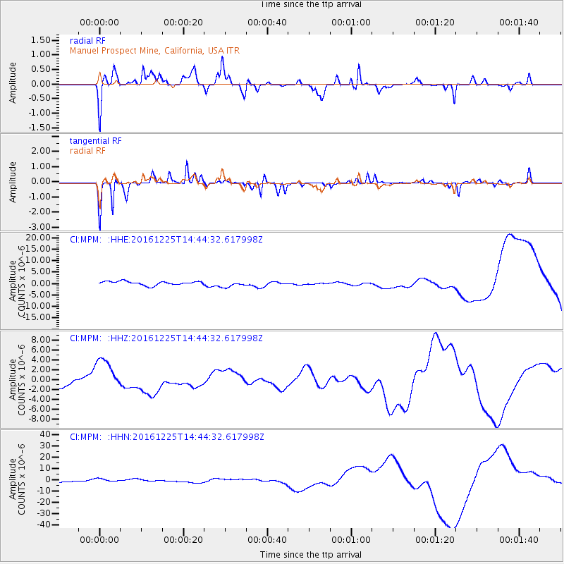
MPM Manuel Prospect Mine, California, USA - Earthquake Result Viewer
*The percent match for this event was below the threshold and hence no stack was calculated.
| Earthquake location: |
Southern Chile |
| Earthquake latitude/longitude: |
-43.5/-74.5 |
| Earthquake time(UTC): |
2016/12/25 (360) 14:32:13 GMT |
| Earthquake Depth: |
17 km |
| Earthquake Magnitude: |
5.6 mb |
| Earthquake Catalog/Contributor: |
NEIC PDE/us |
|
| Network: |
CI Caltech Regional Seismic Network |
| Station: |
MPM Manuel Prospect Mine, California, USA |
| Lat/Lon: |
36.06 N/117.49 W |
| Elevation: |
185 m |
|
| Distance: |
88.3 deg |
| Az: |
326.448 deg |
| Baz: |
150.238 deg |
| Ray Param: |
$rayparam |
*The percent match for this event was below the threshold and hence was not used in the summary stack. |
|
| Radial Match: |
72.15751 % |
| Radial Bump: |
306 |
| Transverse Match: |
81.4354 % |
| Transverse Bump: |
184 |
| SOD ConfigId: |
11737051 |
| Insert Time: |
2019-04-26 10:49:08.019 +0000 |
| GWidth: |
2.5 |
| Max Bumps: |
400 |
| Tol: |
0.001 |
|
Signal To Noise
| Channel | StoN | STA | LTA |
| CI:MPM: :HHZ:20161225T14:44:32.617998Z | 3.924655 | 3.690578E-6 | 9.403573E-7 |
| CI:MPM: :HHN:20161225T14:44:32.617998Z | 1.5958153 | 1.3813461E-6 | 8.656053E-7 |
| CI:MPM: :HHE:20161225T14:44:32.617998Z | 1.6934619 | 1.4051201E-6 | 8.297323E-7 |
| Arrivals |
| Ps | |
| PpPs | |
| PsPs/PpSs | |


