You are here: Home > Network List > CI - Caltech Regional Seismic Network Stations List
> Station TUQ Turquiose Mountain, Baker, CA, USA > Earthquake Result Viewer
TUQ Turquiose Mountain, Baker, CA, USA - Earthquake Result Viewer
| Earthquake location: |
Santiago Del Estero Prov., Arg. |
| Earthquake latitude/longitude: |
-28.6/-65.8 |
| Earthquake time(UTC): |
2004/09/07 (251) 11:53:06 GMT |
| Earthquake Depth: |
22 km |
| Earthquake Magnitude: |
6.1 MB, 6.1 MS, 6.4 MW, 6.2 MW |
| Earthquake Catalog/Contributor: |
WHDF/NEIC |
|
| Network: |
CI Caltech Regional Seismic Network |
| Station: |
TUQ Turquiose Mountain, Baker, CA, USA |
| Lat/Lon: |
35.44 N/115.92 W |
| Elevation: |
1350 m |
|
| Distance: |
79.3 deg |
| Az: |
320.396 deg |
| Baz: |
136.637 deg |
| Ray Param: |
0.049054917 |
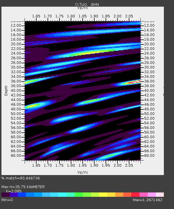
| Estimated Moho Depth: |
35.75 km |
| Estimated Crust Vp/Vs: |
2.10 |
| Assumed Crust Vp: |
6.276 km/s |
| Estimated Crust Vs: |
2.996 km/s |
| Estimated Crust Poisson's Ratio: |
0.35 |
|
| Radial Match: |
90.646736 % |
| Radial Bump: |
400 |
| Transverse Match: |
84.18746 % |
| Transverse Bump: |
400 |
| SOD ConfigId: |
2459 |
| Insert Time: |
2010-03-05 20:57:15.178 +0000 |
| GWidth: |
2.5 |
| Max Bumps: |
400 |
| Tol: |
0.001 |
|
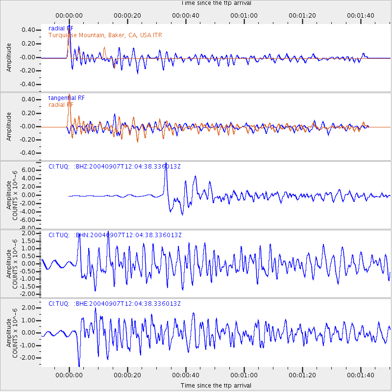
Signal To Noise
| Channel | StoN | STA | LTA |
| CI:TUQ: :BHN:20040907T12:04:38.336013Z | 5.663011 | 7.3719826E-7 | 1.301778E-7 |
| CI:TUQ: :BHE:20040907T12:04:38.336013Z | 5.6059203 | 9.568643E-7 | 1.7068818E-7 |
| CI:TUQ: :BHZ:20040907T12:04:38.336013Z | 22.653854 | 2.8469226E-6 | 1.2567055E-7 |
| Arrivals |
| Ps | 6.4 SECOND |
| PpPs | 17 SECOND |
| PsPs/PpSs | 24 SECOND |


