You are here: Home > Network List > TA - USArray Transportable Network (new EarthScope stations) Stations List
> Station R11A Troy Canyon, Currant, NV, USA > Earthquake Result Viewer
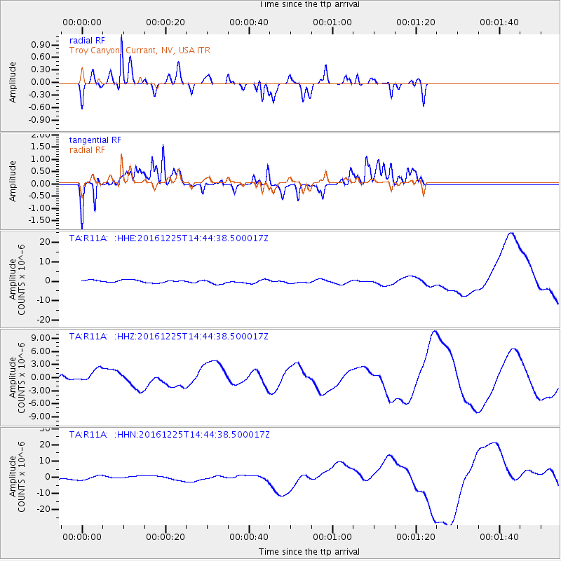
R11A Troy Canyon, Currant, NV, USA - Earthquake Result Viewer
*The percent match for this event was below the threshold and hence no stack was calculated.
| Earthquake location: |
Southern Chile |
| Earthquake latitude/longitude: |
-43.5/-74.5 |
| Earthquake time(UTC): |
2016/12/25 (360) 14:32:13 GMT |
| Earthquake Depth: |
17 km |
| Earthquake Magnitude: |
5.6 mb |
| Earthquake Catalog/Contributor: |
NEIC PDE/us |
|
| Network: |
TA USArray Transportable Network (new EarthScope stations) |
| Station: |
R11A Troy Canyon, Currant, NV, USA |
| Lat/Lon: |
38.35 N/115.59 W |
| Elevation: |
1756 m |
|
| Distance: |
89.6 deg |
| Az: |
328.89 deg |
| Baz: |
151.429 deg |
| Ray Param: |
$rayparam |
*The percent match for this event was below the threshold and hence was not used in the summary stack. |
|
| Radial Match: |
76.59523 % |
| Radial Bump: |
337 |
| Transverse Match: |
70.90185 % |
| Transverse Bump: |
269 |
| SOD ConfigId: |
11737051 |
| Insert Time: |
2019-04-26 10:53:27.243 +0000 |
| GWidth: |
2.5 |
| Max Bumps: |
400 |
| Tol: |
0.001 |
|
Signal To Noise
| Channel | StoN | STA | LTA |
| TA:R11A: :HHZ:20161225T14:44:38.500017Z | 1.5025872 | 1.6328709E-6 | 1.0867062E-6 |
| TA:R11A: :HHN:20161225T14:44:38.500017Z | 1.8892423 | 1.2342548E-6 | 6.5330676E-7 |
| TA:R11A: :HHE:20161225T14:44:38.500017Z | 1.8623669 | 1.2201975E-6 | 6.5518645E-7 |
| Arrivals |
| Ps | |
| PpPs | |
| PsPs/PpSs | |


