You are here: Home > Network List > CI - Caltech Regional Seismic Network Stations List
> Station TUQ Turquiose Mountain, Baker, CA, USA > Earthquake Result Viewer
TUQ Turquiose Mountain, Baker, CA, USA - Earthquake Result Viewer
| Earthquake location: |
Chile-Bolivia Border Region |
| Earthquake latitude/longitude: |
-22.3/-67.9 |
| Earthquake time(UTC): |
2005/11/17 (321) 19:26:56 GMT |
| Earthquake Depth: |
163 km |
| Earthquake Magnitude: |
6.0 MB, 6.9 MW, 6.8 MW |
| Earthquake Catalog/Contributor: |
WHDF/NEIC |
|
| Network: |
CI Caltech Regional Seismic Network |
| Station: |
TUQ Turquiose Mountain, Baker, CA, USA |
| Lat/Lon: |
35.44 N/115.92 W |
| Elevation: |
1350 m |
|
| Distance: |
73.3 deg |
| Az: |
320.654 deg |
| Baz: |
134.035 deg |
| Ray Param: |
0.052682597 |
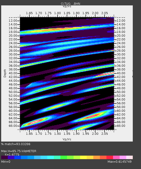
| Estimated Moho Depth: |
65.75 km |
| Estimated Crust Vp/Vs: |
1.68 |
| Assumed Crust Vp: |
6.276 km/s |
| Estimated Crust Vs: |
3.741 km/s |
| Estimated Crust Poisson's Ratio: |
0.22 |
|
| Radial Match: |
93.03286 % |
| Radial Bump: |
400 |
| Transverse Match: |
86.581116 % |
| Transverse Bump: |
400 |
| SOD ConfigId: |
2422 |
| Insert Time: |
2010-03-05 20:57:55.847 +0000 |
| GWidth: |
2.5 |
| Max Bumps: |
400 |
| Tol: |
0.001 |
|
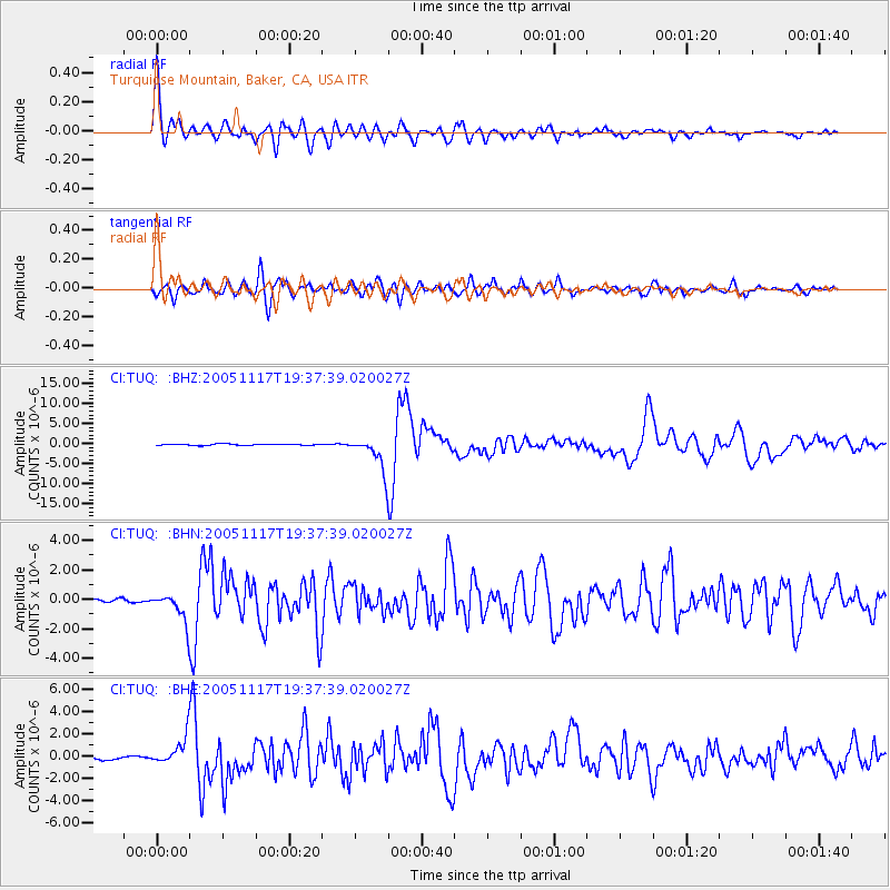
Signal To Noise
| Channel | StoN | STA | LTA |
| CI:TUQ: :BHN:20051117T19:37:39.020027Z | 11.998489 | 9.817754E-7 | 8.1824915E-8 |
| CI:TUQ: :BHE:20051117T19:37:39.020027Z | 8.047135 | 1.228759E-6 | 1.5269521E-7 |
| CI:TUQ: :BHZ:20051117T19:37:39.020027Z | 25.088516 | 4.1813323E-6 | 1.666632E-7 |
| Arrivals |
| Ps | 7.3 SECOND |
| PpPs | 27 SECOND |
| PsPs/PpSs | 34 SECOND |


