You are here: Home > Network List > CI - Caltech Regional Seismic Network Stations List
> Station TUQ Turquiose Mountain, Baker, CA, USA > Earthquake Result Viewer
TUQ Turquiose Mountain, Baker, CA, USA - Earthquake Result Viewer
| Earthquake location: |
Eastern Honshu, Japan |
| Earthquake latitude/longitude: |
39.8/141.5 |
| Earthquake time(UTC): |
2008/07/23 (205) 15:26:19 GMT |
| Earthquake Depth: |
108 km |
| Earthquake Magnitude: |
6.6 MB, 6.8 MW, 6.8 MW |
| Earthquake Catalog/Contributor: |
WHDF/NEIC |
|
| Network: |
CI Caltech Regional Seismic Network |
| Station: |
TUQ Turquiose Mountain, Baker, CA, USA |
| Lat/Lon: |
35.44 N/115.92 W |
| Elevation: |
1350 m |
|
| Distance: |
76.7 deg |
| Az: |
54.983 deg |
| Baz: |
309.411 deg |
| Ray Param: |
0.050591074 |
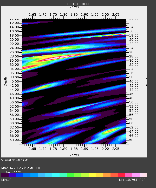
| Estimated Moho Depth: |
28.25 km |
| Estimated Crust Vp/Vs: |
1.78 |
| Assumed Crust Vp: |
6.276 km/s |
| Estimated Crust Vs: |
3.531 km/s |
| Estimated Crust Poisson's Ratio: |
0.27 |
|
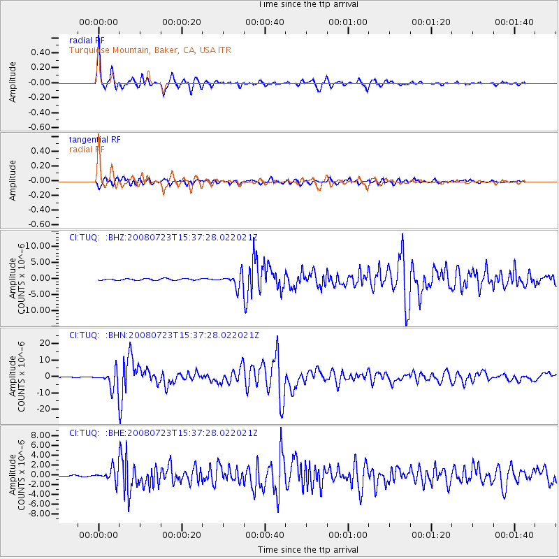
| Radial Match: |
97.64336 % |
| Radial Bump: |
325 |
| Transverse Match: |
88.24421 % |
| Transverse Bump: |
400 |
| SOD ConfigId: |
2504 |
| Insert Time: |
2010-03-05 20:58:29.982 +0000 |
| GWidth: |
2.5 |
| Max Bumps: |
400 |
| Tol: |
0.001 |
|
Signal To Noise
| Channel | StoN | STA | LTA |
| CI:TUQ: :BHN:20080723T15:37:28.022021Z | 28.304777 | 5.855458E-6 | 2.068717E-7 |
| CI:TUQ: :BHE:20080723T15:37:28.022021Z | 8.408192 | 1.3931992E-6 | 1.6569547E-7 |
| CI:TUQ: :BHZ:20080723T15:37:28.022021Z | 8.820284 | 2.1593564E-6 | 2.448171E-7 |
| Arrivals |
| Ps | 3.6 SECOND |
| PpPs | 12 SECOND |
| PsPs/PpSs | 16 SECOND |


