You are here: Home > Network List > TA - USArray Transportable Network (new EarthScope stations) Stations List
> Station A21K Barrow, AK, USA > Earthquake Result Viewer
A21K Barrow, AK, USA - Earthquake Result Viewer
*The percent match for this event was below the threshold and hence no stack was calculated.
| Earthquake location: |
California-Nevada Border Region |
| Earthquake latitude/longitude: |
38.4/-118.9 |
| Earthquake time(UTC): |
2016/12/28 (363) 08:18:00 GMT |
| Earthquake Depth: |
11 km |
| Earthquake Magnitude: |
5.8 ML |
| Earthquake Catalog/Contributor: |
NEIC PDE/nn |
|
| Network: |
TA USArray Transportable Network (new EarthScope stations) |
| Station: |
A21K Barrow, AK, USA |
| Lat/Lon: |
71.32 N/156.62 W |
| Elevation: |
577 m |
|
| Distance: |
38.2 deg |
| Az: |
341.424 deg |
| Baz: |
128.999 deg |
| Ray Param: |
$rayparam |
*The percent match for this event was below the threshold and hence was not used in the summary stack. |
|
| Radial Match: |
77.5328 % |
| Radial Bump: |
400 |
| Transverse Match: |
51.567894 % |
| Transverse Bump: |
393 |
| SOD ConfigId: |
11737051 |
| Insert Time: |
2019-04-26 11:10:25.359 +0000 |
| GWidth: |
2.5 |
| Max Bumps: |
400 |
| Tol: |
0.001 |
|
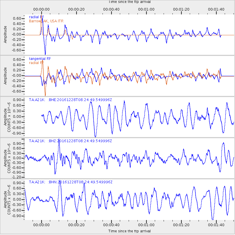
Signal To Noise
| Channel | StoN | STA | LTA |
| TA:A21K: :BHZ:20161228T08:24:49.549996Z | 0.7303222 | 1.3375616E-7 | 1.8314678E-7 |
| TA:A21K: :BHN:20161228T08:24:49.549996Z | 0.18625058 | 6.099573E-8 | 3.274928E-7 |
| TA:A21K: :BHE:20161228T08:24:49.549996Z | 2.046401 | 5.774235E-7 | 2.821654E-7 |
| Arrivals |
| Ps | |
| PpPs | |
| PsPs/PpSs | |


