You are here: Home > Network List > PO - Portable Observatories for Lithospheric Analysis and Research Investigating Seis Stations List
> Station MATQ Matagami, QC > Earthquake Result Viewer
MATQ Matagami, QC - Earthquake Result Viewer
| Earthquake location: |
California-Nevada Border Region |
| Earthquake latitude/longitude: |
38.4/-118.9 |
| Earthquake time(UTC): |
2016/12/28 (363) 09:13:47 GMT |
| Earthquake Depth: |
8.8 km |
| Earthquake Magnitude: |
5.5 ml |
| Earthquake Catalog/Contributor: |
NEIC PDE/nn |
|
| Network: |
PO Portable Observatories for Lithospheric Analysis and Research Investigating Seis |
| Station: |
MATQ Matagami, QC |
| Lat/Lon: |
49.76 N/77.64 W |
| Elevation: |
280 m |
|
| Distance: |
31.4 deg |
| Az: |
55.237 deg |
| Baz: |
264.625 deg |
| Ray Param: |
0.079088174 |
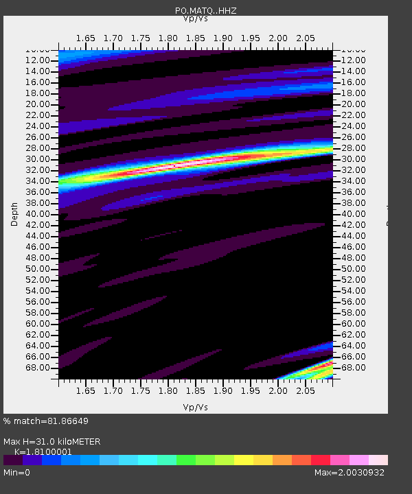
| Estimated Moho Depth: |
31.0 km |
| Estimated Crust Vp/Vs: |
1.81 |
| Assumed Crust Vp: |
6.61 km/s |
| Estimated Crust Vs: |
3.652 km/s |
| Estimated Crust Poisson's Ratio: |
0.28 |
|
| Radial Match: |
81.86649 % |
| Radial Bump: |
400 |
| Transverse Match: |
66.19339 % |
| Transverse Bump: |
400 |
| SOD ConfigId: |
11737051 |
| Insert Time: |
2019-04-26 11:20:16.910 +0000 |
| GWidth: |
2.5 |
| Max Bumps: |
400 |
| Tol: |
0.001 |
|

Signal To Noise
| Channel | StoN | STA | LTA |
| PO:MATQ: :HHZ:20161228T09:19:37.559986Z | 2.1011767 | 1.1654828E-6 | 5.54681E-7 |
| PO:MATQ: :HHN:20161228T09:19:37.559986Z | 0.7317219 | 5.591749E-7 | 7.6419053E-7 |
| PO:MATQ: :HHE:20161228T09:19:37.559986Z | 0.9610529 | 4.7419974E-7 | 4.934169E-7 |
| Arrivals |
| Ps | 4.1 SECOND |
| PpPs | 12 SECOND |
| PsPs/PpSs | 16 SECOND |


