You are here: Home > Network List > TA - USArray Transportable Network (new EarthScope stations) Stations List
> Station F21K Alatna River, AK, USA > Earthquake Result Viewer
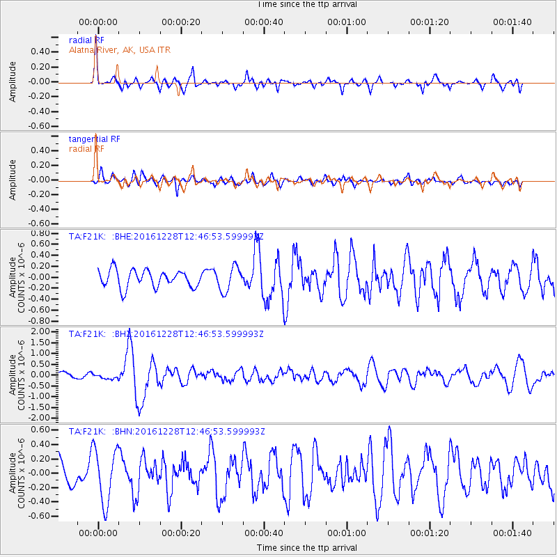
F21K Alatna River, AK, USA - Earthquake Result Viewer
*The percent match for this event was below the threshold and hence no stack was calculated.
| Earthquake location: |
Near East Coast Of Honshu, Japan |
| Earthquake latitude/longitude: |
36.9/140.4 |
| Earthquake time(UTC): |
2016/12/28 (363) 12:38:50 GMT |
| Earthquake Depth: |
10 km |
| Earthquake Magnitude: |
5.9 Mww |
| Earthquake Catalog/Contributor: |
NEIC PDE/us |
|
| Network: |
TA USArray Transportable Network (new EarthScope stations) |
| Station: |
F21K Alatna River, AK, USA |
| Lat/Lon: |
67.22 N/153.48 W |
| Elevation: |
597 m |
|
| Distance: |
47.4 deg |
| Az: |
28.939 deg |
| Baz: |
264.83 deg |
| Ray Param: |
$rayparam |
*The percent match for this event was below the threshold and hence was not used in the summary stack. |
|
| Radial Match: |
62.47714 % |
| Radial Bump: |
400 |
| Transverse Match: |
51.906246 % |
| Transverse Bump: |
400 |
| SOD ConfigId: |
11737051 |
| Insert Time: |
2019-04-26 11:28:00.839 +0000 |
| GWidth: |
2.5 |
| Max Bumps: |
400 |
| Tol: |
0.001 |
|
Signal To Noise
| Channel | StoN | STA | LTA |
| TA:F21K: :BHZ:20161228T12:46:53.599993Z | 0.744854 | 1.1119988E-7 | 1.4929084E-7 |
| TA:F21K: :BHN:20161228T12:46:53.599993Z | 2.1687737 | 3.7246232E-7 | 1.7173868E-7 |
| TA:F21K: :BHE:20161228T12:46:53.599993Z | 1.4671943 | 2.261223E-7 | 1.5411885E-7 |
| Arrivals |
| Ps | |
| PpPs | |
| PsPs/PpSs | |


