You are here: Home > Network List > CI - Caltech Regional Seismic Network Stations List
> Station TUQ Turquiose Mountain, Baker, CA, USA > Earthquake Result Viewer
TUQ Turquiose Mountain, Baker, CA, USA - Earthquake Result Viewer
| Earthquake location: |
Near East Coast Of Honshu, Japan |
| Earthquake latitude/longitude: |
36.4/140.8 |
| Earthquake time(UTC): |
2005/10/19 (292) 11:44:42 GMT |
| Earthquake Depth: |
32 km |
| Earthquake Magnitude: |
6.2 MB, 6.5 MS, 6.4 MW, 6.3 MW |
| Earthquake Catalog/Contributor: |
WHDF/NEIC |
|
| Network: |
CI Caltech Regional Seismic Network |
| Station: |
TUQ Turquiose Mountain, Baker, CA, USA |
| Lat/Lon: |
35.44 N/115.92 W |
| Elevation: |
1350 m |
|
| Distance: |
79.0 deg |
| Az: |
54.065 deg |
| Baz: |
306.878 deg |
| Ray Param: |
0.049194098 |
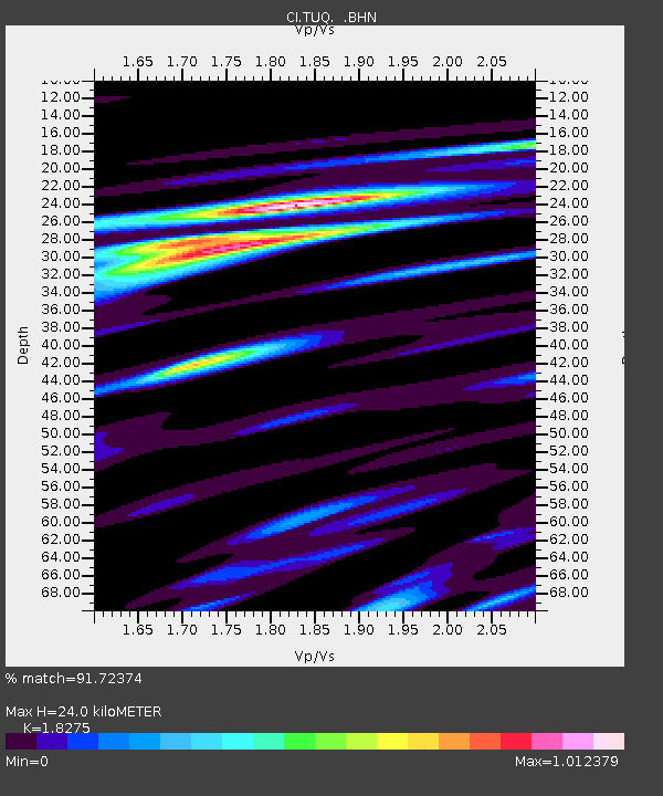
| Estimated Moho Depth: |
24.0 km |
| Estimated Crust Vp/Vs: |
1.83 |
| Assumed Crust Vp: |
6.276 km/s |
| Estimated Crust Vs: |
3.434 km/s |
| Estimated Crust Poisson's Ratio: |
0.29 |
|
| Radial Match: |
91.72374 % |
| Radial Bump: |
400 |
| Transverse Match: |
72.2496 % |
| Transverse Bump: |
400 |
| SOD ConfigId: |
2475 |
| Insert Time: |
2010-03-05 21:00:47.179 +0000 |
| GWidth: |
2.5 |
| Max Bumps: |
400 |
| Tol: |
0.001 |
|
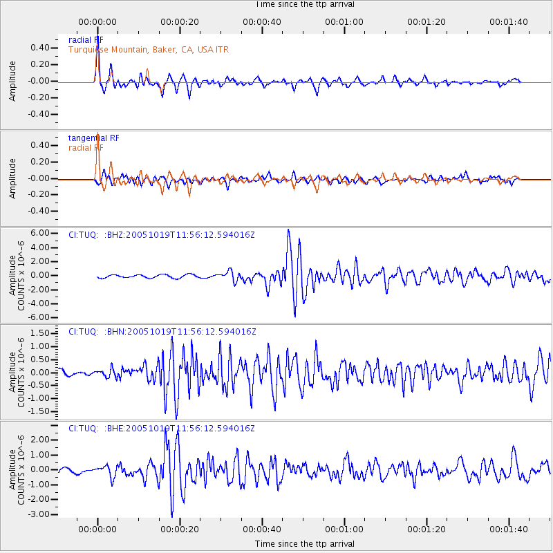
Signal To Noise
| Channel | StoN | STA | LTA |
| CI:TUQ: :BHN:20051019T11:56:12.594016Z | 0.9270688 | 1.5328467E-7 | 1.6534335E-7 |
| CI:TUQ: :BHE:20051019T11:56:12.594016Z | 3.0533352 | 3.8802156E-7 | 1.2708122E-7 |
| CI:TUQ: :BHZ:20051019T11:56:12.594016Z | 2.9979508 | 6.8035797E-7 | 2.26941E-7 |
| Arrivals |
| Ps | 3.3 SECOND |
| PpPs | 11 SECOND |
| PsPs/PpSs | 14 SECOND |


