You are here: Home > Network List > CI - Caltech Regional Seismic Network Stations List
> Station TUQ Turquiose Mountain, Baker, CA, USA > Earthquake Result Viewer
TUQ Turquiose Mountain, Baker, CA, USA - Earthquake Result Viewer
| Earthquake location: |
Hokkaido, Japan Region |
| Earthquake latitude/longitude: |
41.8/143.4 |
| Earthquake time(UTC): |
2009/06/05 (156) 03:30:33 GMT |
| Earthquake Depth: |
29 km |
| Earthquake Magnitude: |
6.0 MB, 6.3 MS, 6.4 MW, 6.4 MW |
| Earthquake Catalog/Contributor: |
WHDF/NEIC |
|
| Network: |
CI Caltech Regional Seismic Network |
| Station: |
TUQ Turquiose Mountain, Baker, CA, USA |
| Lat/Lon: |
35.44 N/115.92 W |
| Elevation: |
1350 m |
|
| Distance: |
74.3 deg |
| Az: |
56.486 deg |
| Baz: |
310.26 deg |
| Ray Param: |
0.052397836 |
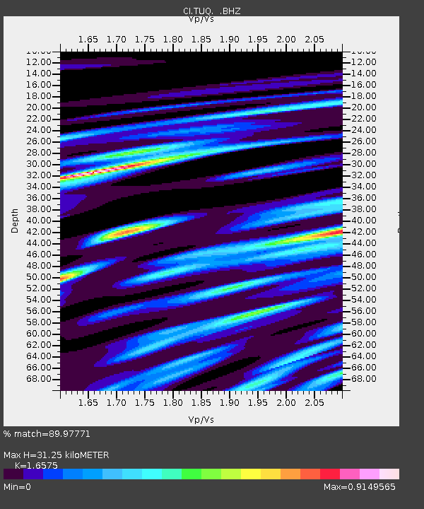
| Estimated Moho Depth: |
31.25 km |
| Estimated Crust Vp/Vs: |
1.66 |
| Assumed Crust Vp: |
6.276 km/s |
| Estimated Crust Vs: |
3.786 km/s |
| Estimated Crust Poisson's Ratio: |
0.21 |
|
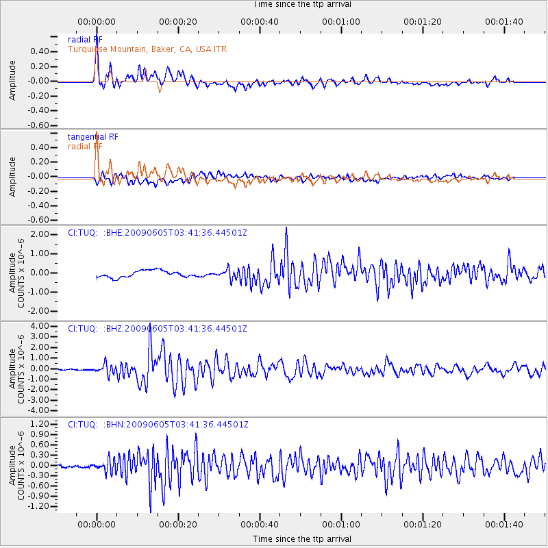
| Radial Match: |
89.97771 % |
| Radial Bump: |
400 |
| Transverse Match: |
73.93388 % |
| Transverse Bump: |
400 |
| SOD ConfigId: |
2648 |
| Insert Time: |
2010-03-05 21:00:49.980 +0000 |
| GWidth: |
2.5 |
| Max Bumps: |
400 |
| Tol: |
0.001 |
|
Signal To Noise
| Channel | StoN | STA | LTA |
| CI:TUQ: :BHZ:20090605T03:41:36.44501Z | 8.355868 | 4.573361E-7 | 5.473233E-8 |
| CI:TUQ: :BHN:20090605T03:41:36.44501Z | 4.9674363 | 1.6835106E-7 | 3.3890935E-8 |
| CI:TUQ: :BHE:20090605T03:41:36.44501Z | 1.3760079 | 2.355623E-7 | 1.7119254E-7 |
| Arrivals |
| Ps | 3.4 SECOND |
| PpPs | 13 SECOND |
| PsPs/PpSs | 16 SECOND |


