You are here: Home > Network List > NR - NARS Array Stations List
> Station NE218 Sowa > Earthquake Result Viewer
NE218 Sowa - Earthquake Result Viewer
| Earthquake location: |
Sumbawa Region, Indonesia |
| Earthquake latitude/longitude: |
-9.1/118.6 |
| Earthquake time(UTC): |
2016/12/29 (364) 22:30:18 GMT |
| Earthquake Depth: |
72 km |
| Earthquake Magnitude: |
6.2 Mwp |
| Earthquake Catalog/Contributor: |
NEIC PDE/us |
|
| Network: |
NR NARS Array |
| Station: |
NE218 Sowa |
| Lat/Lon: |
20.56 S/26.22 E |
| Elevation: |
941 m |
|
| Distance: |
89.1 deg |
| Az: |
249.45 deg |
| Baz: |
99.271 deg |
| Ray Param: |
0.041977033 |
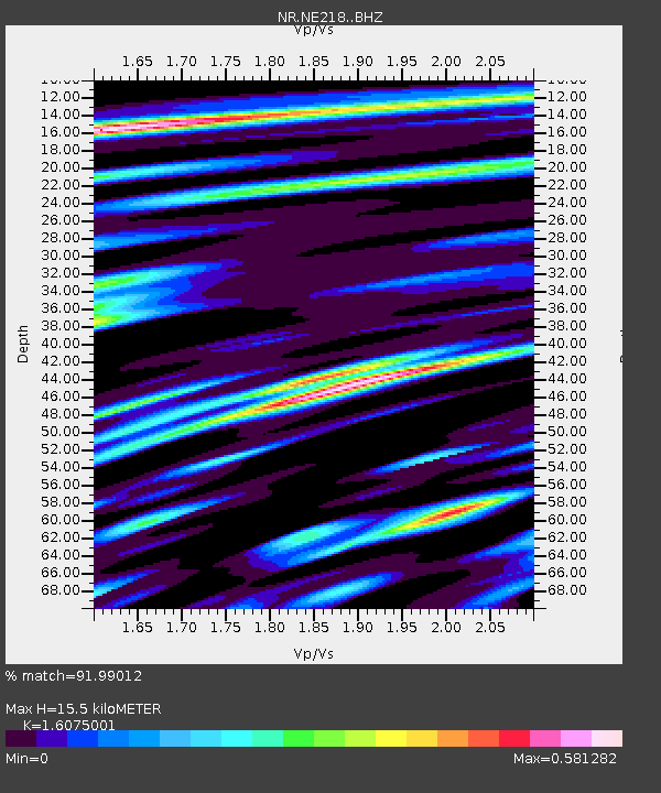
| Estimated Moho Depth: |
15.5 km |
| Estimated Crust Vp/Vs: |
1.61 |
| Assumed Crust Vp: |
6.459 km/s |
| Estimated Crust Vs: |
4.018 km/s |
| Estimated Crust Poisson's Ratio: |
0.18 |
|
| Radial Match: |
91.99012 % |
| Radial Bump: |
400 |
| Transverse Match: |
79.38446 % |
| Transverse Bump: |
400 |
| SOD ConfigId: |
11737051 |
| Insert Time: |
2019-04-26 11:33:39.594 +0000 |
| GWidth: |
2.5 |
| Max Bumps: |
400 |
| Tol: |
0.001 |
|

Signal To Noise
| Channel | StoN | STA | LTA |
| NR:NE218: :BHZ:20161229T22:42:34.881973Z | 26.32065 | 3.253904E-6 | 1.2362551E-7 |
| NR:NE218: :BHN:20161229T22:42:34.881973Z | 4.058753 | 5.803285E-7 | 1.4298197E-7 |
| NR:NE218: :BHE:20161229T22:42:34.881973Z | 11.020788 | 1.2144221E-6 | 1.1019377E-7 |
| Arrivals |
| Ps | 1.5 SECOND |
| PpPs | 6.1 SECOND |
| PsPs/PpSs | 7.6 SECOND |


