You are here: Home > Network List > PF - Volcanologic Network of Piton de Fournaise-OVPF Stations List
> Station BON Bory Nord > Earthquake Result Viewer
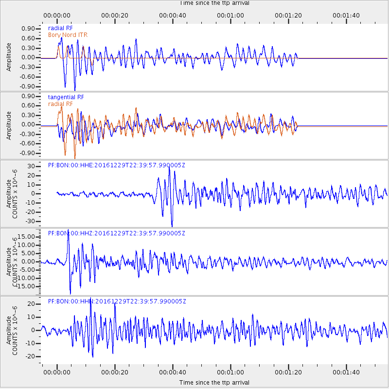
BON Bory Nord - Earthquake Result Viewer
*The percent match for this event was below the threshold and hence no stack was calculated.
| Earthquake location: |
Sumbawa Region, Indonesia |
| Earthquake latitude/longitude: |
-9.1/118.6 |
| Earthquake time(UTC): |
2016/12/29 (364) 22:30:18 GMT |
| Earthquake Depth: |
72 km |
| Earthquake Magnitude: |
6.2 Mwp |
| Earthquake Catalog/Contributor: |
NEIC PDE/us |
|
| Network: |
PF Volcanologic Network of Piton de Fournaise-OVPF |
| Station: |
BON Bory Nord |
| Lat/Lon: |
21.24 S/55.71 E |
| Elevation: |
2552 m |
|
| Distance: |
61.6 deg |
| Az: |
250.801 deg |
| Baz: |
88.957 deg |
| Ray Param: |
$rayparam |
*The percent match for this event was below the threshold and hence was not used in the summary stack. |
|
| Radial Match: |
85.22284 % |
| Radial Bump: |
400 |
| Transverse Match: |
73.79909 % |
| Transverse Bump: |
400 |
| SOD ConfigId: |
11737051 |
| Insert Time: |
2019-04-26 11:33:40.818 +0000 |
| GWidth: |
2.5 |
| Max Bumps: |
400 |
| Tol: |
0.001 |
|
Signal To Noise
| Channel | StoN | STA | LTA |
| PF:BON:00:HHZ:20161229T22:39:57.990005Z | 16.654747 | 7.0321335E-6 | 4.2222996E-7 |
| PF:BON:00:HHN:20161229T22:39:57.990005Z | 1.1288745 | 1.4807108E-6 | 1.3116701E-6 |
| PF:BON:00:HHE:20161229T22:39:57.990005Z | 2.4201782 | 3.5155285E-6 | 1.4525908E-6 |
| Arrivals |
| Ps | |
| PpPs | |
| PsPs/PpSs | |


