You are here: Home > Network List > S - Seismographs in Schools Projects Stations List
> Station AUPHS Peel High School, NSW, Australia > Earthquake Result Viewer
AUPHS Peel High School, NSW, Australia - Earthquake Result Viewer
| Earthquake location: |
Sumbawa Region, Indonesia |
| Earthquake latitude/longitude: |
-9.1/118.6 |
| Earthquake time(UTC): |
2016/12/29 (364) 22:30:18 GMT |
| Earthquake Depth: |
72 km |
| Earthquake Magnitude: |
6.2 Mwp |
| Earthquake Catalog/Contributor: |
NEIC PDE/us |
|
| Network: |
S Seismographs in Schools Projects |
| Station: |
AUPHS Peel High School, NSW, Australia |
| Lat/Lon: |
31.10 S/150.89 E |
| Elevation: |
404 m |
|
| Distance: |
37.2 deg |
| Az: |
130.701 deg |
| Baz: |
299.202 deg |
| Ray Param: |
0.07606392 |
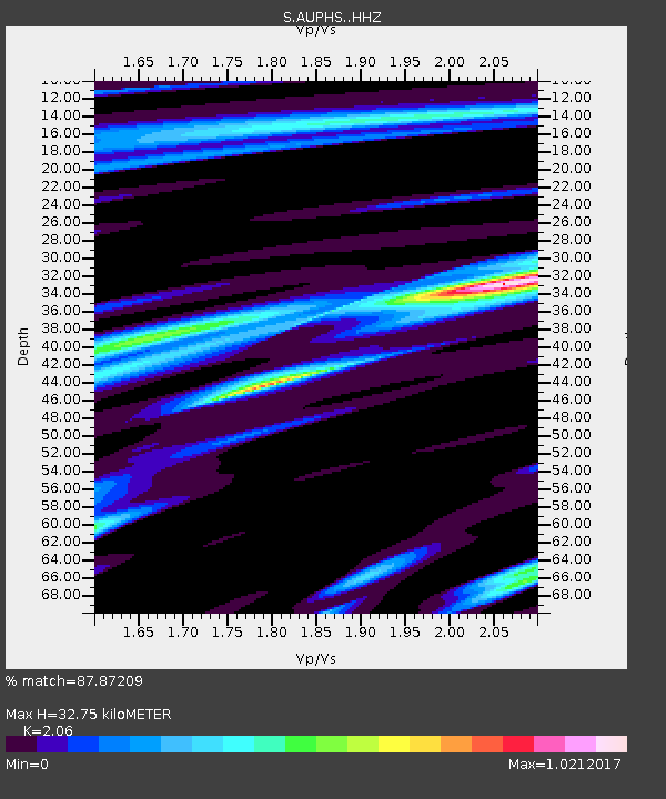
| Estimated Moho Depth: |
32.75 km |
| Estimated Crust Vp/Vs: |
2.06 |
| Assumed Crust Vp: |
6.577 km/s |
| Estimated Crust Vs: |
3.193 km/s |
| Estimated Crust Poisson's Ratio: |
0.35 |
|
| Radial Match: |
87.87209 % |
| Radial Bump: |
323 |
| Transverse Match: |
59.677784 % |
| Transverse Bump: |
400 |
| SOD ConfigId: |
11737051 |
| Insert Time: |
2019-04-26 11:33:57.381 +0000 |
| GWidth: |
2.5 |
| Max Bumps: |
400 |
| Tol: |
0.001 |
|

Signal To Noise
| Channel | StoN | STA | LTA |
| S:AUPHS: :HHZ:20161229T22:36:52.259994Z | 28.011112 | 6.8316394E-6 | 2.4389033E-7 |
| S:AUPHS: :HHN:20161229T22:36:52.259994Z | 8.856106 | 2.2611423E-6 | 2.5532017E-7 |
| S:AUPHS: :HHE:20161229T22:36:52.259994Z | 15.400799 | 3.6012489E-6 | 2.338352E-7 |
| Arrivals |
| Ps | 5.6 SECOND |
| PpPs | 14 SECOND |
| PsPs/PpSs | 20 SECOND |


