You are here: Home > Network List > S - Seismographs in Schools Projects Stations List
> Station AUTKS The King's School, Parramatta, NSW > Earthquake Result Viewer
AUTKS The King's School, Parramatta, NSW - Earthquake Result Viewer
| Earthquake location: |
Sumbawa Region, Indonesia |
| Earthquake latitude/longitude: |
-9.1/118.6 |
| Earthquake time(UTC): |
2016/12/29 (364) 22:30:18 GMT |
| Earthquake Depth: |
72 km |
| Earthquake Magnitude: |
6.2 Mwp |
| Earthquake Catalog/Contributor: |
NEIC PDE/us |
|
| Network: |
S Seismographs in Schools Projects |
| Station: |
AUTKS The King's School, Parramatta, NSW |
| Lat/Lon: |
33.78 S/151.03 E |
| Elevation: |
95 m |
|
| Distance: |
38.6 deg |
| Az: |
134.36 deg |
| Baz: |
302.02 deg |
| Ray Param: |
0.07522376 |
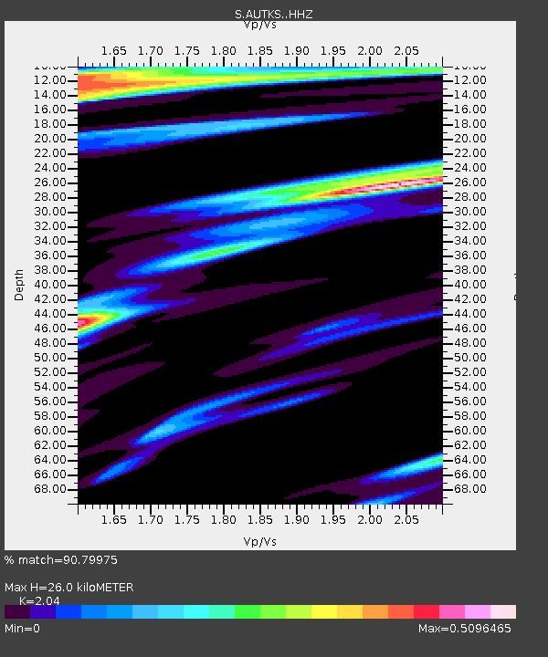
| Estimated Moho Depth: |
26.0 km |
| Estimated Crust Vp/Vs: |
2.04 |
| Assumed Crust Vp: |
6.548 km/s |
| Estimated Crust Vs: |
3.21 km/s |
| Estimated Crust Poisson's Ratio: |
0.34 |
|
| Radial Match: |
90.79975 % |
| Radial Bump: |
316 |
| Transverse Match: |
69.33502 % |
| Transverse Bump: |
400 |
| SOD ConfigId: |
11737051 |
| Insert Time: |
2019-04-26 11:34:02.912 +0000 |
| GWidth: |
2.5 |
| Max Bumps: |
400 |
| Tol: |
0.001 |
|

Signal To Noise
| Channel | StoN | STA | LTA |
| S:AUTKS: :HHZ:20161229T22:37:04.560012Z | 20.835264 | 8.966681E-6 | 4.3036079E-7 |
| S:AUTKS: :HHN:20161229T22:37:04.560012Z | 5.4812403 | 2.041945E-6 | 3.7253338E-7 |
| S:AUTKS: :HHE:20161229T22:37:04.560012Z | 9.225243 | 3.2404973E-6 | 3.512642E-7 |
| Arrivals |
| Ps | 4.4 SECOND |
| PpPs | 11 SECOND |
| PsPs/PpSs | 16 SECOND |


