You are here: Home > Network List > G - GEOSCOPE Stations List
> Station SANVU Espiritu Santo, Vanuatu > Earthquake Result Viewer
SANVU Espiritu Santo, Vanuatu - Earthquake Result Viewer
| Earthquake location: |
Timor Region |
| Earthquake latitude/longitude: |
-8.4/124.9 |
| Earthquake time(UTC): |
2015/11/04 (308) 03:44:15 GMT |
| Earthquake Depth: |
14 km |
| Earthquake Magnitude: |
6.3 MWP |
| Earthquake Catalog/Contributor: |
NEIC PDE/NEIC COMCAT |
|
| Network: |
G GEOSCOPE |
| Station: |
SANVU Espiritu Santo, Vanuatu |
| Lat/Lon: |
15.45 S/167.20 E |
| Elevation: |
56 m |
|
| Distance: |
41.9 deg |
| Az: |
103.764 deg |
| Baz: |
274.681 deg |
| Ray Param: |
0.073466204 |
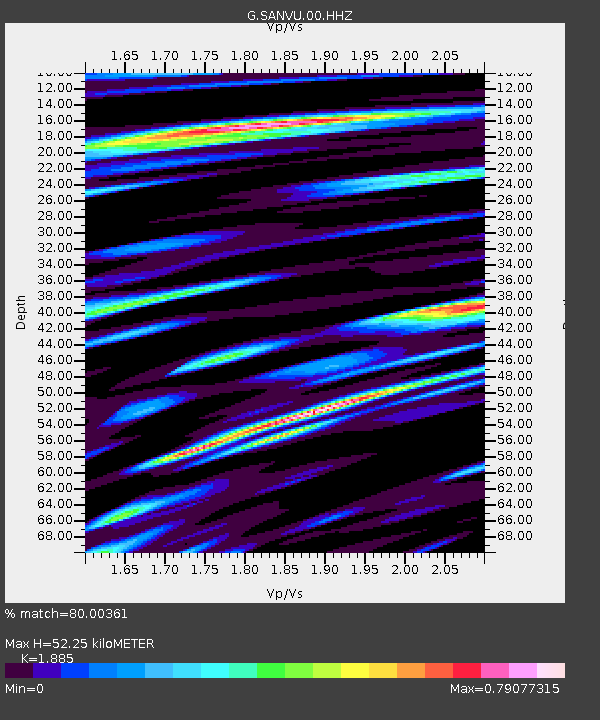
| Estimated Moho Depth: |
52.25 km |
| Estimated Crust Vp/Vs: |
1.88 |
| Assumed Crust Vp: |
4.802 km/s |
| Estimated Crust Vs: |
2.547 km/s |
| Estimated Crust Poisson's Ratio: |
0.30 |
|
| Radial Match: |
80.00361 % |
| Radial Bump: |
400 |
| Transverse Match: |
67.64409 % |
| Transverse Bump: |
400 |
| SOD ConfigId: |
1259291 |
| Insert Time: |
2015-11-18 04:10:00.030 +0000 |
| GWidth: |
2.5 |
| Max Bumps: |
400 |
| Tol: |
0.001 |
|

Signal To Noise
| Channel | StoN | STA | LTA |
| G:SANVU:00:HHZ:20151104T03:51:34.508986Z | 11.814265 | 3.3392887E-6 | 2.8264887E-7 |
| G:SANVU:00:HHN:20151104T03:51:34.508986Z | 0.8339616 | 4.935604E-7 | 5.918263E-7 |
| G:SANVU:00:HHE:20151104T03:51:34.508986Z | 4.3398023 | 1.7564398E-6 | 4.0472807E-7 |
| Arrivals |
| Ps | 10.0 SECOND |
| PpPs | 30 SECOND |
| PsPs/PpSs | 40 SECOND |


