You are here: Home > Network List > TA - USArray Transportable Network (new EarthScope stations) Stations List
> Station F21K Alatna River, AK, USA > Earthquake Result Viewer
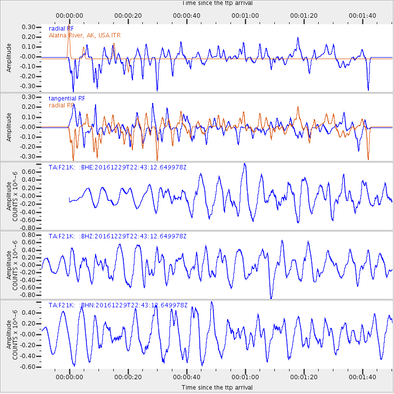
F21K Alatna River, AK, USA - Earthquake Result Viewer
*The percent match for this event was below the threshold and hence no stack was calculated.
| Earthquake location: |
Sumbawa Region, Indonesia |
| Earthquake latitude/longitude: |
-9.1/118.6 |
| Earthquake time(UTC): |
2016/12/29 (364) 22:30:18 GMT |
| Earthquake Depth: |
72 km |
| Earthquake Magnitude: |
6.2 Mwp |
| Earthquake Catalog/Contributor: |
NEIC PDE/us |
|
| Network: |
TA USArray Transportable Network (new EarthScope stations) |
| Station: |
F21K Alatna River, AK, USA |
| Lat/Lon: |
67.22 N/153.48 W |
| Elevation: |
597 m |
|
| Distance: |
97.5 deg |
| Az: |
23.107 deg |
| Baz: |
264.55 deg |
| Ray Param: |
$rayparam |
*The percent match for this event was below the threshold and hence was not used in the summary stack. |
|
| Radial Match: |
58.850204 % |
| Radial Bump: |
400 |
| Transverse Match: |
48.11924 % |
| Transverse Bump: |
400 |
| SOD ConfigId: |
11737051 |
| Insert Time: |
2019-04-26 11:34:08.902 +0000 |
| GWidth: |
2.5 |
| Max Bumps: |
400 |
| Tol: |
0.001 |
|
Signal To Noise
| Channel | StoN | STA | LTA |
| TA:F21K: :BHZ:20161229T22:43:12.649978Z | 1.4525794 | 2.669313E-7 | 1.8376365E-7 |
| TA:F21K: :BHN:20161229T22:43:12.649978Z | 1.6985213 | 3.6728164E-7 | 2.1623612E-7 |
| TA:F21K: :BHE:20161229T22:43:12.649978Z | 1.2722394 | 1.9464078E-7 | 1.5299068E-7 |
| Arrivals |
| Ps | |
| PpPs | |
| PsPs/PpSs | |


