You are here: Home > Network List > YT07 - POLENET Stations List
> Station RMBO RMBO > Earthquake Result Viewer
RMBO RMBO - Earthquake Result Viewer
| Earthquake location: |
Sumbawa Region, Indonesia |
| Earthquake latitude/longitude: |
-9.1/118.6 |
| Earthquake time(UTC): |
2016/12/29 (364) 22:30:18 GMT |
| Earthquake Depth: |
72 km |
| Earthquake Magnitude: |
6.2 Mwp |
| Earthquake Catalog/Contributor: |
NEIC PDE/us |
|
| Network: |
YT POLENET |
| Station: |
RMBO RMBO |
| Lat/Lon: |
83.87 S/66.40 W |
| Elevation: |
800 m |
|
| Distance: |
87.1 deg |
| Az: |
179.462 deg |
| Baz: |
184.949 deg |
| Ray Param: |
0.04339927 |
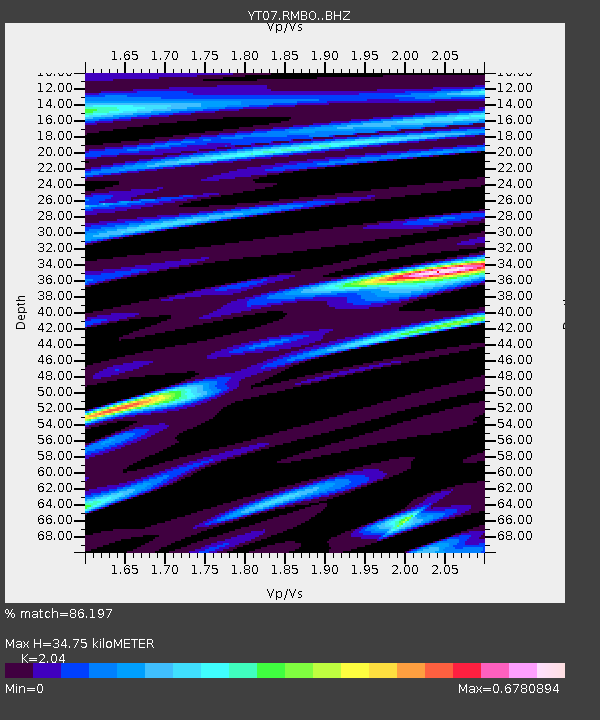
| Estimated Moho Depth: |
34.75 km |
| Estimated Crust Vp/Vs: |
2.04 |
| Assumed Crust Vp: |
6.356 km/s |
| Estimated Crust Vs: |
3.116 km/s |
| Estimated Crust Poisson's Ratio: |
0.34 |
|
| Radial Match: |
86.197 % |
| Radial Bump: |
400 |
| Transverse Match: |
77.52231 % |
| Transverse Bump: |
400 |
| SOD ConfigId: |
11737051 |
| Insert Time: |
2019-04-26 11:34:44.755 +0000 |
| GWidth: |
2.5 |
| Max Bumps: |
400 |
| Tol: |
0.001 |
|

Signal To Noise
| Channel | StoN | STA | LTA |
| YT:RMBO: :BHZ:20161229T22:42:25.549026Z | 14.387789 | 6.895643E-7 | 4.792705E-8 |
| YT:RMBO: :BHN:20161229T22:42:25.549026Z | 2.224285 | 1.3592441E-7 | 6.110926E-8 |
| YT:RMBO: :BHE:20161229T22:42:25.549026Z | 2.1184971 | 1.3348726E-7 | 6.301036E-8 |
| Arrivals |
| Ps | 5.8 SECOND |
| PpPs | 16 SECOND |
| PsPs/PpSs | 22 SECOND |


