You are here: Home > Network List > CI - Caltech Regional Seismic Network Stations List
> Station TUQ Turquiose Mountain, Baker, CA, USA > Earthquake Result Viewer
TUQ Turquiose Mountain, Baker, CA, USA - Earthquake Result Viewer
| Earthquake location: |
Kuril Islands |
| Earthquake latitude/longitude: |
46.0/151.5 |
| Earthquake time(UTC): |
2009/04/07 (097) 04:23:33 GMT |
| Earthquake Depth: |
31 km |
| Earthquake Magnitude: |
6.5 MB, 6.8 MS, 6.9 MW, 6.9 MW |
| Earthquake Catalog/Contributor: |
WHDF/NEIC |
|
| Network: |
CI Caltech Regional Seismic Network |
| Station: |
TUQ Turquiose Mountain, Baker, CA, USA |
| Lat/Lon: |
35.44 N/115.92 W |
| Elevation: |
1350 m |
|
| Distance: |
67.1 deg |
| Az: |
62.325 deg |
| Baz: |
310.948 deg |
| Ray Param: |
0.057129744 |
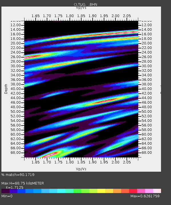
| Estimated Moho Depth: |
68.75 km |
| Estimated Crust Vp/Vs: |
1.71 |
| Assumed Crust Vp: |
6.276 km/s |
| Estimated Crust Vs: |
3.665 km/s |
| Estimated Crust Poisson's Ratio: |
0.24 |
|
| Radial Match: |
90.1719 % |
| Radial Bump: |
381 |
| Transverse Match: |
67.72219 % |
| Transverse Bump: |
400 |
| SOD ConfigId: |
2658 |
| Insert Time: |
2010-03-05 21:01:57.182 +0000 |
| GWidth: |
2.5 |
| Max Bumps: |
400 |
| Tol: |
0.001 |
|
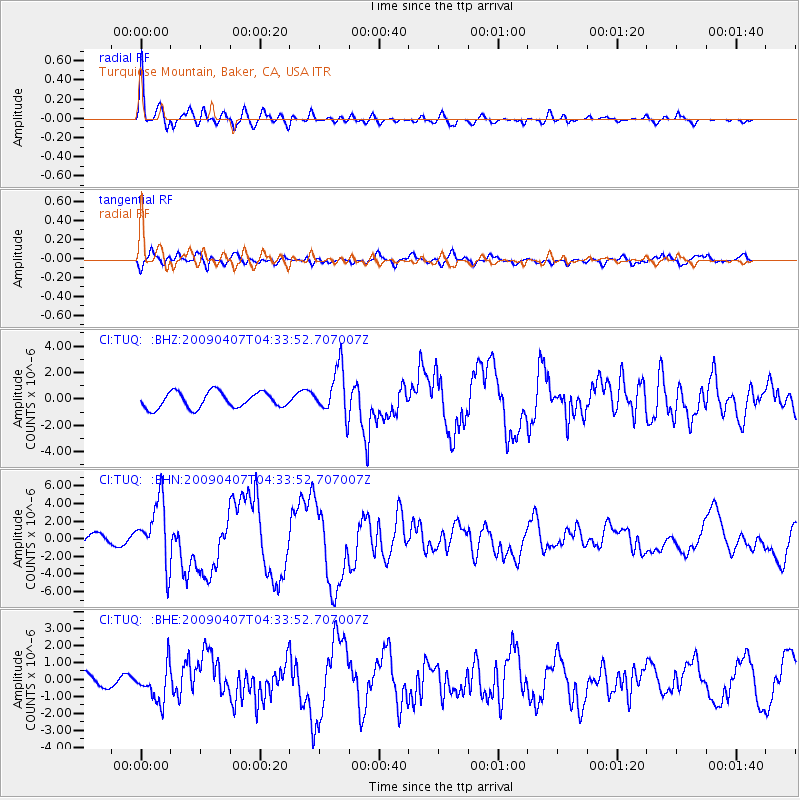
Signal To Noise
| Channel | StoN | STA | LTA |
| CI:TUQ: :BHN:20090407T04:33:52.707007Z | 4.985739 | 3.5739154E-6 | 7.168276E-7 |
| CI:TUQ: :BHE:20090407T04:33:52.707007Z | 2.4557068 | 1.0611906E-6 | 4.3213242E-7 |
| CI:TUQ: :BHZ:20090407T04:33:52.707007Z | 3.018115 | 1.8036006E-6 | 5.9759174E-7 |
| Arrivals |
| Ps | 8.1 SECOND |
| PpPs | 29 SECOND |
| PsPs/PpSs | 37 SECOND |


