You are here: Home > Network List > TA - USArray Transportable Network (new EarthScope stations) Stations List
> Station A21K Barrow, AK, USA > Earthquake Result Viewer
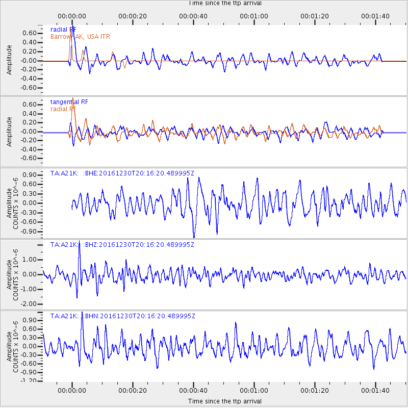
A21K Barrow, AK, USA - Earthquake Result Viewer
*The percent match for this event was below the threshold and hence no stack was calculated.
| Earthquake location: |
Near East Coast Of Honshu, Japan |
| Earthquake latitude/longitude: |
37.4/141.4 |
| Earthquake time(UTC): |
2016/12/30 (365) 20:08:27 GMT |
| Earthquake Depth: |
12 km |
| Earthquake Magnitude: |
5.5 mb |
| Earthquake Catalog/Contributor: |
NEIC PDE/us |
|
| Network: |
TA USArray Transportable Network (new EarthScope stations) |
| Station: |
A21K Barrow, AK, USA |
| Lat/Lon: |
71.32 N/156.62 W |
| Elevation: |
577 m |
|
| Distance: |
46.1 deg |
| Az: |
23.236 deg |
| Baz: |
257.222 deg |
| Ray Param: |
$rayparam |
*The percent match for this event was below the threshold and hence was not used in the summary stack. |
|
| Radial Match: |
71.71855 % |
| Radial Bump: |
400 |
| Transverse Match: |
58.997887 % |
| Transverse Bump: |
400 |
| SOD ConfigId: |
11737051 |
| Insert Time: |
2019-04-26 11:42:35.831 +0000 |
| GWidth: |
2.5 |
| Max Bumps: |
400 |
| Tol: |
0.001 |
|
Signal To Noise
| Channel | StoN | STA | LTA |
| TA:A21K: :BHZ:20161230T20:16:20.489995Z | 3.8224125 | 7.783805E-7 | 2.0363593E-7 |
| TA:A21K: :BHN:20161230T20:16:20.489995Z | 1.6680824 | 4.023817E-7 | 2.4122411E-7 |
| TA:A21K: :BHE:20161230T20:16:20.489995Z | 1.2038984 | 2.8042962E-7 | 2.329346E-7 |
| Arrivals |
| Ps | |
| PpPs | |
| PsPs/PpSs | |


