You are here: Home > Network List > TA - USArray Transportable Network (new EarthScope stations) Stations List
> Station F31M Tsiigehtchic, NWT, CAN > Earthquake Result Viewer
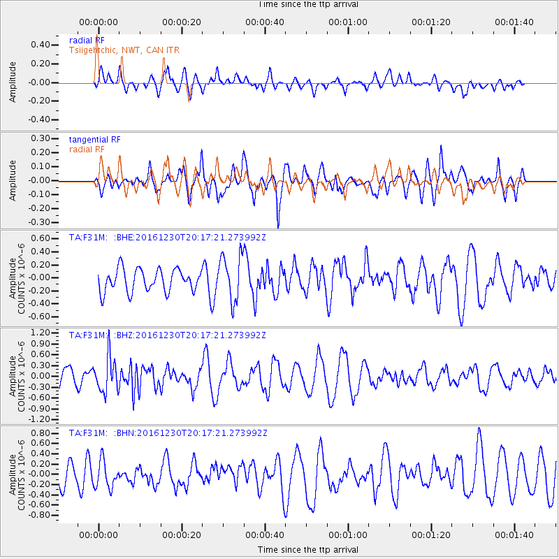
F31M Tsiigehtchic, NWT, CAN - Earthquake Result Viewer
*The percent match for this event was below the threshold and hence no stack was calculated.
| Earthquake location: |
Near East Coast Of Honshu, Japan |
| Earthquake latitude/longitude: |
37.4/141.4 |
| Earthquake time(UTC): |
2016/12/30 (365) 20:08:27 GMT |
| Earthquake Depth: |
12 km |
| Earthquake Magnitude: |
5.5 mb |
| Earthquake Catalog/Contributor: |
NEIC PDE/us |
|
| Network: |
TA USArray Transportable Network (new EarthScope stations) |
| Station: |
F31M Tsiigehtchic, NWT, CAN |
| Lat/Lon: |
67.44 N/133.74 W |
| Elevation: |
56 m |
|
| Distance: |
54.2 deg |
| Az: |
28.297 deg |
| Baz: |
281.914 deg |
| Ray Param: |
$rayparam |
*The percent match for this event was below the threshold and hence was not used in the summary stack. |
|
| Radial Match: |
49.819225 % |
| Radial Bump: |
400 |
| Transverse Match: |
45.47615 % |
| Transverse Bump: |
400 |
| SOD ConfigId: |
11737051 |
| Insert Time: |
2019-04-26 11:42:43.358 +0000 |
| GWidth: |
2.5 |
| Max Bumps: |
400 |
| Tol: |
0.001 |
|
Signal To Noise
| Channel | StoN | STA | LTA |
| TA:F31M: :BHZ:20161230T20:17:21.273992Z | 1.9462289 | 4.9472396E-7 | 2.5419618E-7 |
| TA:F31M: :BHN:20161230T20:17:21.273992Z | 1.3220693 | 2.648037E-7 | 2.0029486E-7 |
| TA:F31M: :BHE:20161230T20:17:21.273992Z | 2.1711414 | 3.7498765E-7 | 1.7271452E-7 |
| Arrivals |
| Ps | |
| PpPs | |
| PsPs/PpSs | |


