You are here: Home > Network List > IU - Global Seismograph Network (GSN - IRIS/USGS) Stations List
> Station MAKZ Makanchi, Kazakhstan > Earthquake Result Viewer
MAKZ Makanchi, Kazakhstan - Earthquake Result Viewer

| Earthquake location: |
Sulawesi, Indonesia |
| Earthquake latitude/longitude: |
-1.9/122.6 |
| Earthquake time(UTC): |
2019/04/12 (102) 11:40:49 GMT |
| Earthquake Depth: |
17 km |
| Earthquake Magnitude: |
6.8 Mww |
| Earthquake Catalog/Contributor: |
NEIC PDE/us |
|
| Network: |
IU Global Seismograph Network (GSN - IRIS/USGS) |
| Station: |
MAKZ Makanchi, Kazakhstan |
| Lat/Lon: |
46.81 N/81.98 E |
| Elevation: |
600 m |
|
| Distance: |
60.1 deg |
| Az: |
328.985 deg |
| Baz: |
131.431 deg |
| Ray Param: |
0.061722413 |
| Estimated Moho Depth: |
52.5 km |
| Estimated Crust Vp/Vs: |
1.74 |
| Assumed Crust Vp: |
6.571 km/s |
| Estimated Crust Vs: |
3.782 km/s |
| Estimated Crust Poisson's Ratio: |
0.25 |
|
| Radial Match: |
97.92463 % |
| Radial Bump: |
286 |
| Transverse Match: |
89.52 % |
| Transverse Bump: |
400 |
| SOD ConfigId: |
11735903 |
| Insert Time: |
2019-04-26 11:45:31.877 +0000 |
| GWidth: |
2.5 |
| Max Bumps: |
400 |
| Tol: |
0.001 |
|
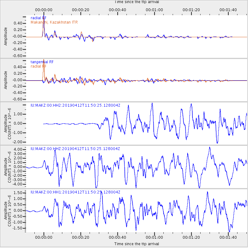
Signal To Noise
| Channel | StoN | STA | LTA |
| IU:MAKZ:00:HHZ:20190412T11:50:25.128004Z | 16.706339 | 1.0699965E-6 | 6.4047335E-8 |
| IU:MAKZ:00:HH1:20190412T11:50:25.128004Z | 9.379582 | 3.0485793E-7 | 3.2502292E-8 |
| IU:MAKZ:00:HH2:20190412T11:50:25.128004Z | 11.879733 | 3.834186E-7 | 3.2275018E-8 |
| Arrivals |
| Ps | 6.2 SECOND |
| PpPs | 21 SECOND |
| PsPs/PpSs | 27 SECOND |


