You are here: Home > Network List > TA - USArray Transportable Network (new EarthScope stations) Stations List
> Station R33M Jennings River, BC, CAN > Earthquake Result Viewer
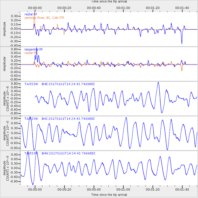
R33M Jennings River, BC, CAN - Earthquake Result Viewer
*The percent match for this event was below the threshold and hence no stack was calculated.
| Earthquake location: |
North Of Halmahera, Indonesia |
| Earthquake latitude/longitude: |
3.6/128.6 |
| Earthquake time(UTC): |
2017/01/01 (001) 14:12:09 GMT |
| Earthquake Depth: |
35 km |
| Earthquake Magnitude: |
5.5 mb |
| Earthquake Catalog/Contributor: |
NEIC PDE/us |
|
| Network: |
TA USArray Transportable Network (new EarthScope stations) |
| Station: |
R33M Jennings River, BC, CAN |
| Lat/Lon: |
59.39 N/130.97 W |
| Elevation: |
1437 m |
|
| Distance: |
92.2 deg |
| Az: |
30.235 deg |
| Baz: |
280.83 deg |
| Ray Param: |
$rayparam |
*The percent match for this event was below the threshold and hence was not used in the summary stack. |
|
| Radial Match: |
63.387676 % |
| Radial Bump: |
368 |
| Transverse Match: |
68.97963 % |
| Transverse Bump: |
400 |
| SOD ConfigId: |
11737051 |
| Insert Time: |
2019-04-26 11:48:15.700 +0000 |
| GWidth: |
2.5 |
| Max Bumps: |
400 |
| Tol: |
0.001 |
|
Signal To Noise
| Channel | StoN | STA | LTA |
| TA:R33M: :BHZ:20170101T14:24:43.749988Z | 1.6587117 | 5.79893E-7 | 3.4960448E-7 |
| TA:R33M: :BHN:20170101T14:24:43.749988Z | 2.291638 | 7.4846184E-7 | 3.2660563E-7 |
| TA:R33M: :BHE:20170101T14:24:43.749988Z | 1.0950872 | 2.315411E-7 | 2.1143622E-7 |
| Arrivals |
| Ps | |
| PpPs | |
| PsPs/PpSs | |


