You are here: Home > Network List > CI - Caltech Regional Seismic Network Stations List
> Station TUQ Turquiose Mountain, Baker, CA, USA > Earthquake Result Viewer
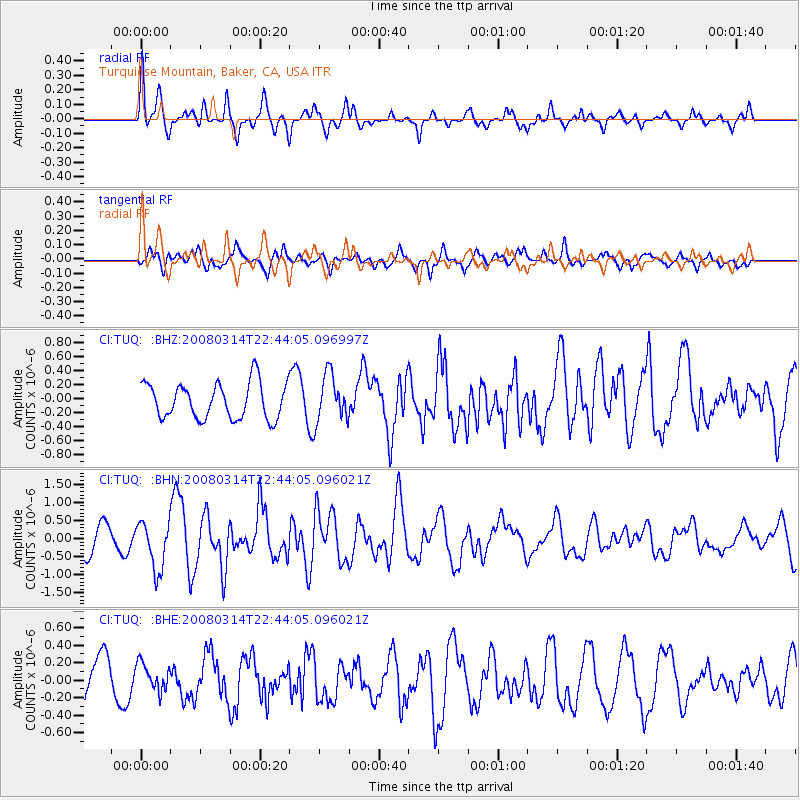
TUQ Turquiose Mountain, Baker, CA, USA - Earthquake Result Viewer
*The percent match for this event was below the threshold and hence no stack was calculated.
| Earthquake location: |
Bonin Islands, Japan Region |
| Earthquake latitude/longitude: |
27.0/142.6 |
| Earthquake time(UTC): |
2008/03/14 (074) 22:32:09 GMT |
| Earthquake Depth: |
11 km |
| Earthquake Magnitude: |
5.7 MB, 5.9 MS, 6.0 MW, 6.0 MW |
| Earthquake Catalog/Contributor: |
WHDF/NEIC |
|
| Network: |
CI Caltech Regional Seismic Network |
| Station: |
TUQ Turquiose Mountain, Baker, CA, USA |
| Lat/Lon: |
35.44 N/115.92 W |
| Elevation: |
1350 m |
|
| Distance: |
83.4 deg |
| Az: |
53.674 deg |
| Baz: |
298.311 deg |
| Ray Param: |
$rayparam |
*The percent match for this event was below the threshold and hence was not used in the summary stack. |
|
| Radial Match: |
71.08172 % |
| Radial Bump: |
400 |
| Transverse Match: |
62.13791 % |
| Transverse Bump: |
400 |
| SOD ConfigId: |
2504 |
| Insert Time: |
2010-03-05 21:02:55.632 +0000 |
| GWidth: |
2.5 |
| Max Bumps: |
400 |
| Tol: |
0.001 |
|
Signal To Noise
| Channel | StoN | STA | LTA |
| CI:TUQ: :BHN:20080314T22:44:05.096021Z | 1.8307024 | 6.561035E-7 | 3.5838895E-7 |
| CI:TUQ: :BHE:20080314T22:44:05.096021Z | 0.6901055 | 1.5402006E-7 | 2.2318335E-7 |
| CI:TUQ: :BHZ:20080314T22:44:05.096997Z | 1.3199029 | 3.341757E-7 | 2.5318204E-7 |
| Arrivals |
| Ps | |
| PpPs | |
| PsPs/PpSs | |


