You are here: Home > Network List > TA - USArray Transportable Network (new EarthScope stations) Stations List
> Station D23K Nanushuk River, AK USA > Earthquake Result Viewer
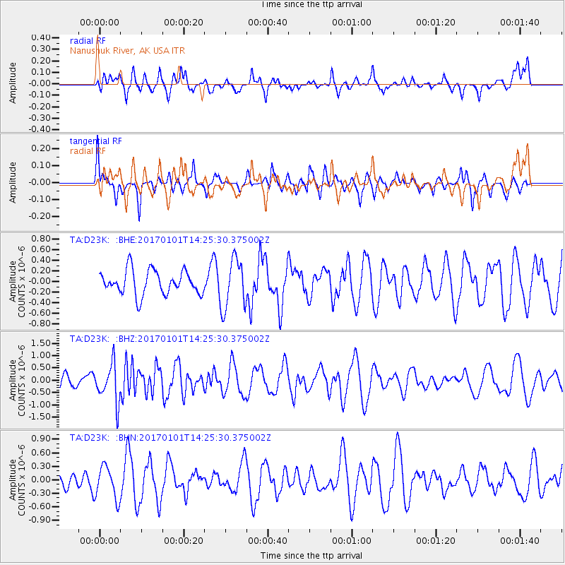
D23K Nanushuk River, AK USA - Earthquake Result Viewer
*The percent match for this event was below the threshold and hence no stack was calculated.
| Earthquake location: |
North Of Halmahera, Indonesia |
| Earthquake latitude/longitude: |
3.6/128.2 |
| Earthquake time(UTC): |
2017/01/01 (001) 14:13:37 GMT |
| Earthquake Depth: |
35 km |
| Earthquake Magnitude: |
5.5 mb |
| Earthquake Catalog/Contributor: |
NEIC PDE/us |
|
| Network: |
TA USArray Transportable Network (new EarthScope stations) |
| Station: |
D23K Nanushuk River, AK USA |
| Lat/Lon: |
68.97 N/150.68 W |
| Elevation: |
406 m |
|
| Distance: |
83.5 deg |
| Az: |
21.04 deg |
| Baz: |
262.979 deg |
| Ray Param: |
$rayparam |
*The percent match for this event was below the threshold and hence was not used in the summary stack. |
|
| Radial Match: |
67.35463 % |
| Radial Bump: |
400 |
| Transverse Match: |
46.09817 % |
| Transverse Bump: |
371 |
| SOD ConfigId: |
11737051 |
| Insert Time: |
2019-04-26 11:52:12.757 +0000 |
| GWidth: |
2.5 |
| Max Bumps: |
400 |
| Tol: |
0.001 |
|
Signal To Noise
| Channel | StoN | STA | LTA |
| TA:D23K: :BHZ:20170101T14:25:30.375002Z | 1.8006829 | 7.863795E-7 | 4.367118E-7 |
| TA:D23K: :BHN:20170101T14:25:30.375002Z | 1.623498 | 3.6222116E-7 | 2.2311156E-7 |
| TA:D23K: :BHE:20170101T14:25:30.375002Z | 1.9814141 | 4.477194E-7 | 2.2595952E-7 |
| Arrivals |
| Ps | |
| PpPs | |
| PsPs/PpSs | |


