You are here: Home > Network List > TA - USArray Transportable Network (new EarthScope stations) Stations List
> Station N25K Chitina, Valdez-Cordova, AK, USA > Earthquake Result Viewer
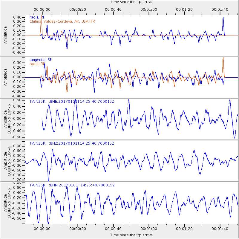
N25K Chitina, Valdez-Cordova, AK, USA - Earthquake Result Viewer
*The percent match for this event was below the threshold and hence no stack was calculated.
| Earthquake location: |
North Of Halmahera, Indonesia |
| Earthquake latitude/longitude: |
3.6/128.2 |
| Earthquake time(UTC): |
2017/01/01 (001) 14:13:37 GMT |
| Earthquake Depth: |
35 km |
| Earthquake Magnitude: |
5.5 mb |
| Earthquake Catalog/Contributor: |
NEIC PDE/us |
|
| Network: |
TA USArray Transportable Network (new EarthScope stations) |
| Station: |
N25K Chitina, Valdez-Cordova, AK, USA |
| Lat/Lon: |
61.61 N/144.60 W |
| Elevation: |
1087 m |
|
| Distance: |
85.5 deg |
| Az: |
28.613 deg |
| Baz: |
269.237 deg |
| Ray Param: |
$rayparam |
*The percent match for this event was below the threshold and hence was not used in the summary stack. |
|
| Radial Match: |
56.360897 % |
| Radial Bump: |
400 |
| Transverse Match: |
51.092243 % |
| Transverse Bump: |
400 |
| SOD ConfigId: |
11737051 |
| Insert Time: |
2019-04-26 11:52:22.664 +0000 |
| GWidth: |
2.5 |
| Max Bumps: |
400 |
| Tol: |
0.001 |
|
Signal To Noise
| Channel | StoN | STA | LTA |
| TA:N25K: :BHZ:20170101T14:25:40.700015Z | 2.865259 | 5.3629174E-7 | 1.8717043E-7 |
| TA:N25K: :BHN:20170101T14:25:40.700015Z | 2.9473393 | 4.88985E-7 | 1.6590727E-7 |
| TA:N25K: :BHE:20170101T14:25:40.700015Z | 0.38532227 | 1.13564944E-7 | 2.9472716E-7 |
| Arrivals |
| Ps | |
| PpPs | |
| PsPs/PpSs | |


